On the September 2009 GSA field forum in the Owens Valley, the final stop of our first day was to check out the so-called “Crucifix Site,” along Chalk Bluff Road (north of Bishop, California, at the southern margin of the Volcanic Tableland). It’s called the “Crucifix Site” because there is a metal cross erected there:
This is the site of some pre-Bishop-Tuff volcaniclastic sediments. The place is interesting on several levels, including the sediments themselves, and the subsequent deformation they have experienced. Here’s a look at the outcrop:
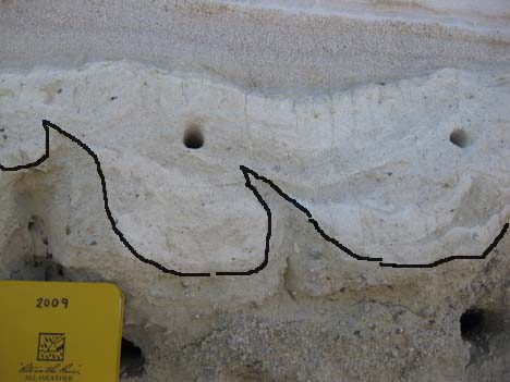
Some annotations help to call one’s attention to primary sedimentary structures and interpretations: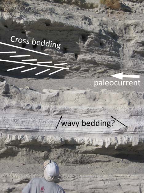
Lots of the sediment itself was made of little beads of obsidian, usually surrounded with a “chalky” weathering rind:
A cool little channel cross-section was visible, too: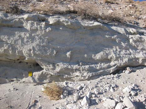
For some reason, this is what pops into my mind when I run into a well-exposed Cheshire channel cross-section:
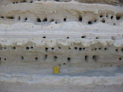
Birds and wasps had tunneled into the softer layers, resulting in horizontal rows of holes. I tried to ignore these modern bioturbations so I could focus on the ancient tale in the rocks themselves. Some cool soft sediment deformation was visible, like these flame structures (upper part of the central gray layer):
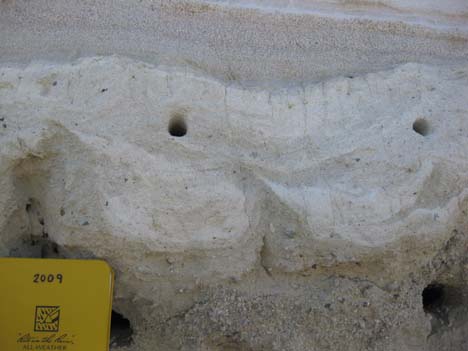
Zoomed in on a pair of flame structures, and the down-sagged material between them: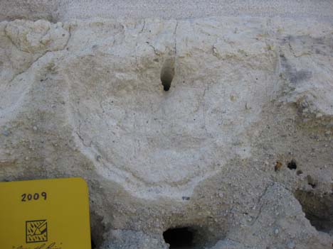
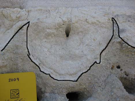
This was odd: The lowermost layer (upon which my field notebook rests) is unperturbed, but the layers above it are all churned up in one small area (center), flanked by a couple of bird holes:

Zoomed-in on the area in question:
Annotated, for your viewing pleasure; green is top of undisturbed layer; red shows boundaries of zone of disrupted sediment: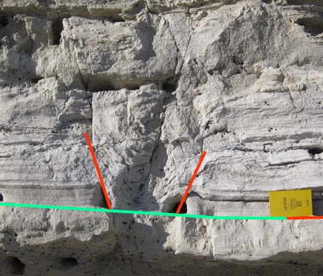
I would be pleased to hear from anyone who knows more about sedimentology than me about the wavy bedding in the second (& third) photo, and this weird sediment disturbance in the lowermost photo. Also: with the flame structures, it looks like coarser material in the lower layer (gray) is the less viscous participant, while finer-grained (white) material is sinking downwards. Isn’t this the opposite of the way it usually works?

Nice outcrop indeed! I’ll just shout some things I thought of:
Wavy layering. Might they’ve been formed by wave action? For instance that the sediments have been deposited in an offshore environment not deeper than the wave base depth.
Sediment disturbance (last photo): My mind sprang towards frost wedges, but not quite. The flame structures also made me think of post-depositional perturbance by frost. But I can’t recall the precise mechanisms and processes and such.
Just my thoughts.
Hi Remy,
Thanks for your thoughts. I think it’s pretty clear these are terrestrial sediments, not marine. The “chalk” talk may have thrown you off — though there’s plenty of light-colored, fine-grained sediment here with a “chalky” texture, there’s no calcium carbonate in it.
They’re also quite young — older than 76,000 years (the age of the Bishop Tuff which overlies them), but not much more than that. After all, they’re still at the surface in the Owens Valley, which is down-dropping over time. The area hasn’t been submerged beneath the ocean probably since the Cretaceous (my guess — I’ll be pleased to be corrected by anyone who knows of marine units in the Owens Valley younger than Cretaceous but older than the Bishop Tuff).
CB
Yeah, looks like a lot of loading and related soft-sed deformation to me as you say.
The one labeled as ‘wavy bedding’ could be more loading type of deformation rather than primary bedforms. Especially since it’s localized like that and that there is a lot of deformation in the rest of the section.
In terms of flames and load structures, yes an overlying coarser unit is typically what’s seen as loading down w/ finer units ‘injecting’ up and creating the flames. But, I’ve seen it the other way as well (silt loading into sand) — what’s needed is a density contrast — and if the underlying bed had already mostly dewatered then a new flow/event could be sufficiently dense enough to sink in.
As for the final photograph — dang, that’s kinda weird looking. When I see something like where the geometries just don’t seem to work out then I invoke the unseen 3rd dimension. That is, perhaps the rest of the deformation explaining this a bit more came out and/or went into the outcrop.
Good thought on that last one. I’ll ponder the third dimension… Thanks, Brian!
I’m wondering if in that last photo the disturbance doesn’t just barely go into that lower bed,, even though you’ve drawn a straight line. Maybe.
Earthquake sand blow in cross-section?
I think certain flow regimes can produce wavy bedding, although I think I would lean toward some type of synsedimentary deformation.
Got me beat on the other thing, although it looks a lot like a sauropod or mammoth track in cross-section; it’s even about the right size.
Alton: As it’s Pleistocene, though, I think it’s the wrong age for sauropods! 🙂
Plus, the whole perplexing deal with it is that the strata below aren’t deformed at all. I would expect at least some deflection or squishing with a big impactor like that.
I don’t actually think a trackway is likely! But…
Pleistocene could be an elephant rather than a sauropod. I’ve seen similar tracks in Pleistocene lacustrine deposits (there’s one on exhibit at Mammoth Site in SD, for example, caused by a Columbian mammoth).
Also, the disturbance you see would most likely be the underprint, rather than the track itself. A heavy animal like an elephant or a sauropod can deform sediment for some distance below the surface (I think up to a meter or so, depending on various factors). Essentially, what you’re seeing is the “squish”; the trackway itself would be higher. To make it even more exciting, in a setting like this one, you could have a track produced, that disturbs sediment for some distance below, and then the track itself is eroded away, leaving the underprint disturbance as the only record that a track was there at all. At some depth below the print the track disturbance finally dampens out. The undisturbed unit may have been slightly more lithified or compacted, and deep enough below the print, to be below the disturbance.
You can actually see this sort of thing if you’ve ever done beach transects in wet sand. When digging the transect you have to stay away from the edges of the pit because even a human foot can disturb the sediment to a depth of several inches. The track disturbance sometimes is even delimited by small normal faults; it’s not always a gradual compaction across a broad area.
It turns out that underprints are quite common. The famous front-print-only sauropod tracks are explained this way. This was a trackway that consisted only of front feet from a sauropod dinosaur; it was originally used as evidence that a sauropod was swimming, pulling itself along with its front feet. It was later shown that it was in fact an underprint feature. Because sauropod front feet were smaller than the back feet, the weight per unit area was greater on the front feet, and so the front feet disturbed the sediment to a greater depth. Subsequent erosion removed the tracks and the entire back foot underprints, but left the slightly deeper front foot underprints behind.