
In today’s post, I’ll finish up with my geologic discussion of the falls of the James River in Richmond Virginia, south of Belle Isle. Previously, we’ve examined the bedrock at this location (the Petersburg Granite) and a series of fractures – some faults and some extensional joints – that deform that granite. Now we come to the final chapter in this story — the story of the river carving up these rocks as it incises downward along the Fall Zone.
Unlike my native Potomac River, there is no gorge carved along the James at the boundary between the metamorphic & igneous rocks of the Piedmont and the overlying Coastal Plain strata to the east.
But there is still some cool stuff to see. In my first post on Belle Isle, I mentioned the diversion dam that keeps the river-bottom bedrock (mostly) dry and available to geological scrutiny. That dam diverted some of the James River into a mill race which led to a hydroelectric power plant that was abandoned a half-century ago. Here’s a map showing the dam, mill race, and some other key features:
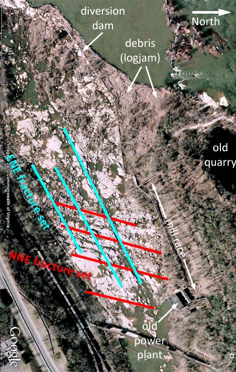
You’ll note that’s a Google Earth image that I’ve rotated 90° clockwise to fit it into this vertical-friendly blog space. North is to the right. I’ve highlighted the trends of the NNE- and ENE-oriented fracture sets that I discussed here yesterday, as well as the quarry pond on the north side of Belle Isle. You’ll also note a Δ-shaped logjam at the intake for the mill race. The mill race itself is choked with mud (the bigger debris is strained out at the inlet; but the mud makes it through). There are some mudcracks visible there:
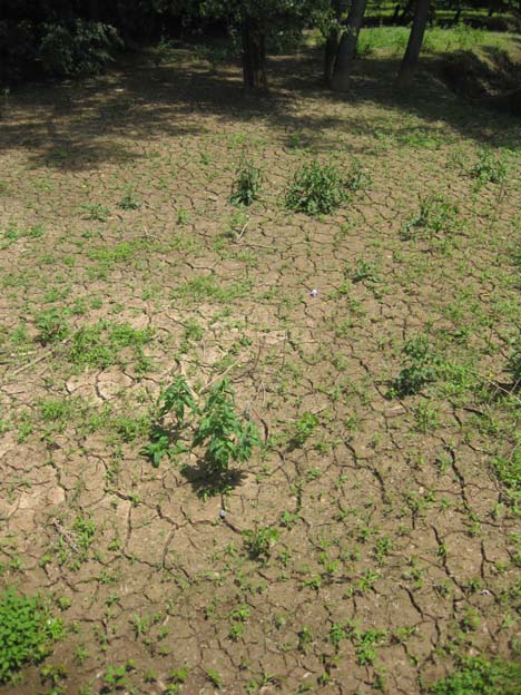
Chuck is trying to talk a colleague into drilling a sediment core through this deposit — easily two meters thick. It might potentially provide an interesting sedimentological (and geochemical) account of the last 50 years.
Let’s zoom in further to the ~dry area of the river bed south of Belle Isle; the part the dam makes accessible to sunbathers, dope-smokers, fisherman, graffiti-artists, and geologists:
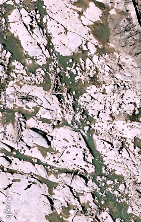
Again, north is to the right. You’ll note the obvious trend of the two dominant fracture sets, as well as a large number of elliptical ‘dots.’ These dots are potholes, semi-cylindrical holes that get drilled into the bedrock when water currents maintain vortices (plural of vortex: think a liquid tornado) in one place over an extended period of time. Some of these potholes line up in rows — like perforations at the top of a checkbook, these aligned potholes create planes of weakness that make it easier to pop out large slabs of rock in a quarrying process not unlike what humans do with their ‘plug & feather’ techniques.
In the close-up Google Earth image, at the lower left (southeast), you can see that I’ve placed a pair of black arrows pointing to a train of four potholes. One has a big boulder in it, and then there are three others with an elongated axis in the NNE-direction. We visited this particular chain of holes, and saw something interesting.
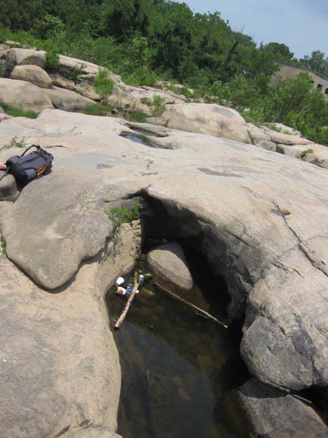
Here’s Chuck standing in the second pothole, with the boulder-containing pothole in the foreground:
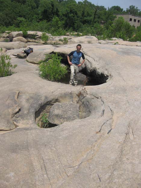
You can just barely make out the two more northerly potholes in the far distance, but here’s a second shot showing them from the vantage of the northerly tip of the second pothole. The backpack and power plant should provide orienting landmarks:
Now take a look at that first photo again — take particular note of the magmatic schlieren in the bedrock. Recall that schlieren are curtain-like zones of more mafic minerals in the granite. You can see that the schlieren wrap around these potholes. Here, I’ll trace them out (crudely) for you:
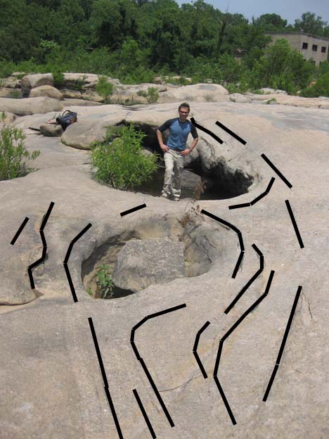
Potholes are recent geomorphological features imparted by the river. The schlieren formed ~320 million years ago — how could the older structure wrap around the younger carving? Chuck interprets this to mean that the potholes were etched out from some weaker/less stable rock type — perhaps some of the mafic-composition xenoliths that pepper the Petersburg Granite in this area. Certainly, we can see that the xenoliths often appear in long trains, strung out along the plane of magmatic foliation, and the schlieren wrap around those. If the river exploits the outcropping xenoliths as areas where it’s easier to drill, the ancient positioning of the xenoliths could lead to the modern positioning of the potholes. I’ve seen something very similar on the Billy Goat Trail (Potomac River, downstream of Great Falls), so it wasn’t too difficult for me to buy into this interpretation.
Have any of my readers seeing compositional variations (like xenoliths) controlling river geomorphology elsewhere? Do tell!
Finally, thanks again to Chuck for taking the time to show us around last Friday. Belle Isle is a cool place on many levels, and I’m glad I got the chance to check it out in person.
Hi, I’d like to cheerfully volunteer to be your first young earth creationist follower–I have a BS/MS in geology, but have been “retired” to raise kids for 20+ years, and am just starting to get back into geology again. I enjoy the give and take between different positions, and am comfortable with multiple working hypotheses. I have a comment on the schlieren–do all the potholes have them, or just some? If all the potholes have schlieren, but none maintain the original inclusion as in the photo you linked to, one may consider the possibility that they formed concurrently, regardless of what the dating says.
Most potholes do not display “wrap-around” schlieren. This particular set was unique in my experience at Belle Isle.
Not sure what to say about a young Earth creationist who is “comfortable with multiple working hypotheses.” Perhaps this: Is it okay to retain hypotheses that are disproved by evidence?
Depends on the nature of the hypothesis and the quality of the evidence. I’ve been discussing this issue for over 20 years with my skeptical attorney husband, and I’ve learned to be very clear about assumptions and very precise about definitions. However, I’m not following this blog to debate, but to look at cool pictures and learn more about geology, though if I can offer a contrasting viewpoint, I’ll do so (I found the site while searching for images .of plumose structures and hackles). Plus, my husband is a DC-bred, Georgetown Law grad, I got my Master’s at George Washington while working for NOAA in Rockville, and we have a lot of family in DC, so I’m looking forward to finding out more about the geology of the area. It’s a very informative site–keep up the good work.