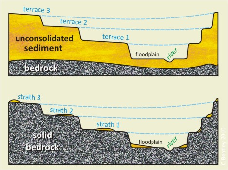
There is an old Chinese aphorism that “the beginning of wisdom is to call things by their proper names.” One of the naming conventions that tends to trip up NOVA students who hike the Billy Goat Trail with me is the difference between a “terrace” and a “strath.” This morning, I created a graphic that illustrates the difference between these two landforms as I understand it:
Both features are shown in cross-sectional cartoon view. Terraces are cut into alluvium, the unconsolidated sediment deposited by the same river which is now incising. Straths, on the other hand, have the same shape but are etched into bedrock. Another name for straths would be “bedrock terraces.” Straths will sometimes have a thin veneer of alluvium atop them: in my experience along the Billy Goat Trail, this consists of abandoned bedload from older, higher base levels, augmented by lighter-weight flood deposits.
Would anyone with more geomorphological knowledge than me care to qualify / critique / correct my understanding on this terminological issue? Thanks in advance!
UPDATE: Based on Anne’s comments below, I’ve tweaked it a bit:


You’ve got the terminology about right…Both are called terraces, but the upper one is a cut-and-fill terrace while the lower one is a strath terrace. While the difference in materials in the two cross-sections is important, the thing that most interests geomorphologists is this difference in implied river incision history. Cut-and-fill terraces, where the unconsolidated sediments are actually alluvium, show that the river has had periods of both aggradation and incision (and lateral planation of the valley bottom). In rivers with strath terraces, aggradational periods are either relatively minor or non-existent and the terraces represent alternating periods of incision and lateral planation. In both cases, terrace formation can be driven by changes in climate or tectonics/baselevel. My favorite paper on strath terrace formation is that by Hancock and Anderson (2002).
Thanks Anne!
Question Anne,
The upper layers of strata are the oldest in this situation correct? Those layers being the original stream beds as the river downcut to present level?
Would the flat area to the side of the tiny river bed be terracepr strath 4, or is that just the floodplain? And are they always numbered from the top down like that?
The flat area to the side of the river bed would be the active flood plain, most likely. Terraces are sometimes (always?) numbered from the bottom up.
I’ve labeled the floodplain in the new version (added at bottom of the original post) and changed the numbering order. It chafes at my sense of chronological ordering, but I’ll defer to those with more expertise in the conventions than me.
: )
Wonderful post, and nice clarification by Anne–you guys are amazing writers.
We are starting to experiment with ice as bedrock in our river models, and you two have given us a perfect beginning point!
The numbering issue comes up often in mapping. I think that it is best to number in order of deposition. There can always be a new terrace / fan / feature, so you just increment the number if you update the map.Interestingly however, the usgs guide to authors of maps and pubs suggests thats terraces be mapped from the bottom up while fans be numbered in depositional order. Thus, when mapping fans graded to terraces, the numbers of coeval features are out of synch…if you were to follow the scheme…which just seems wrong. Thus, I don’t do it. I have waffled in the past about the numbering scheme (and have some maps to prove it), but have decided that numbering all features in order of deposition makes the most sense.
Thanks for weighing in, Kyle. I figured you’d know for sure about the terrace numbering. Your explanation for why to number from top down makes complete sense, I’d just seen lots of pubs maps done the other way, so I was confused. Thanks for the explanation!
Thanks Kyle – I’m facing the same issue working in western Wisconsin. My colleague has numbered the late Pleistocene high terrace last, the lowest holocene terrace T1…
New paper on our local ridge here in Ellensburg, Washington. Couldn’t remember what a strath terrace was and found this. Thanks!
🙂
Years later… Writer with a biology background here. I’m writing a govt. report on plants in the Sonoran Desert and ran across the word strath (Larson, Phillip H., and Ronald I. Dorn. “Strath development in small arid watersheds: Case study of South Mountain, Sonoran Desert, Arizona.” American Journal of Science 314.8 (2014): 1202-1223.). I wanted a graphic to more fully understand. Your illustration and written descriptions are great! Thank you.
How would you all classify a stream incising through till deposits (neither bedrock nor earlier alluvium)?
Great question. The concept is closer to a terrace than a strath…