
Jason Buchheim, one of the people I met last week in Pittsburgh, just posted a Gigapan of images stitched together from the Mars Observer MER HiRise. Part of it jumped out at me as being similar to the map pattern we see on Earth where an angular unconformity outcrops:
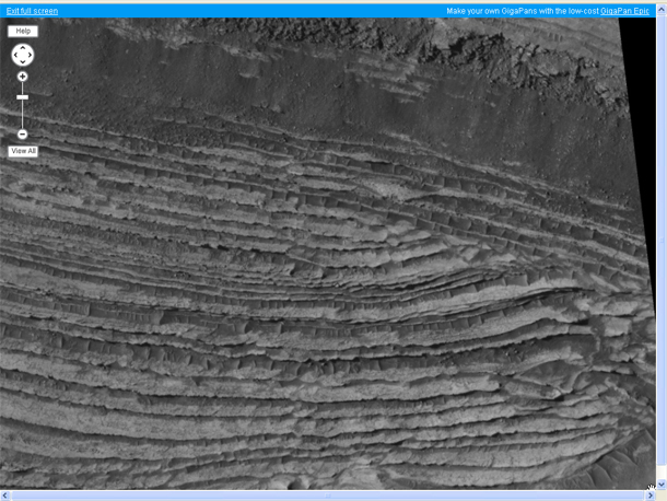
Here, I’ve highlighted the pattern which caught my eye:
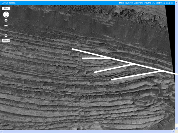
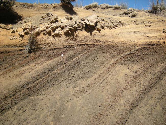
On the other hand, the increasing inflection of the “lower” (in the photo) strata towards the right suggests maybe this is just cross bedding, like this example in pyroclastic deposits on Mauna Kea, Hawai’i:
What do you think? Explore Jason’s Gigapan on your own and let me know your thoughts. Especially you, Ryan!
I think, only looking at the image, that it seems more cross bedding rather than unconformity. The angle of inflection changes to a lower angle to the left.
Also, as a thought, it could be some kind old of roll-over fold.
Wow, spectacular layers! It’s always difficult to tell whether the patterns seen in eroded, layered landscapes like this are due to the erosion or the actual geometry of the beds, but there’s definitely something going on here! I think an angular unconformity is probably more likely than cross-beds because it would be strange to see just this one example of cross-bedding with all the surrounding beds looking nice and parallel. Also, if you look on the left edge of the image in the same package of layers, there’s another example that looks to me like it might be an unconformity… A 3d view of this would help a lot: any idea what the HiRISE image ID is, and if it’s part of a stereo pair?
That, I don’t know. Only what Jason put up on the Gigapan page — we might query him there for additional details, and maybe a link to the source imagery.
What’s the scale on this image? The interpretation is surely very dependent on that…
According to a post on Twitter, the whole image is about 6km wide.
The swath size for HiRISE images is 6km or greater.
Hi,
This is part of a stereo pair, but we are having trouble converting the other HiRise image into a Tiff as the JPEG2000 file size is so large and the programs that can deal with very large JPEG2000 are limited.
The links here are purposefully “broken”, the files are a Gigabyte each, so think before you download them.
httpbroken://pds-imaging.jpl.nasa.gov/data/mro/mars_reconnaissance_orbiter/ctx/mrox_0028/data/P02_001918_1735_XI_06S076W.IMG
httpbroken://pds-imaging.jpl.nasa.gov/data/mro/mars_reconnaissance_orbiter/ctx/mrox_0031/data/P02_001984_1735_XI_06S076W.IMG
they’re in PDS format.
When I get the stereo pair generated and aligned I will post it on Gigapan, in the meantime, check out http://www.3dpan.org, on the bottom I have some more Mars stereo imagery.
Thanks
Jason
Any idea what kind of rock these are? Are there fluvial systems nearby or is this on the edge of the northern lowlands? If it were on the margin of a large lake or the possible northern ‘sea’, then it could be argued that it’s a partial sedimentary sequence.
Deposition could have filled accommodation space (the lower part) up until all space was full, at the ‘unconformity’, and then deposition stopped. Then a period of quiescence until either the land subsided or water level rose enough for material to deposit over the entire package. In the middle of the photo, on the left side of the drawn guidelines, notice how the ‘uncomformity’ goes away? To the left, the layers are actually conformable: To me this looks exactly like the transition from a highstand systems tract to a transgression. Also, we know that Mars experiences orbital climatic cycles just like the Earth, which could explain why the water levels could change.
You know how it goes, you see what you know. And I’ve seen these types of structures in the field, in largescale maps, and in seismic. But of course it could be something else too. Depending on scale, it could be some very large crossbedding (not sure whether fluvial (floods can make massive waves, e.g. the Snake river) or eolian, or something else too….
I meant to say a low stand systems tract to transgression systems tract boundary. But still, it looks like a sedimentary sequence boundary to me….
if you look closely at the gigapan, there are many faults that are clearly offsetting layers. It’s beautiful!
I’m not a sediment person, but isn’t cross-bedding technically a form of angular unconformity, just at a much faster scale? I think I understand that cross bedding forms by putting down some layers, then truncating them and putting down more on top, whilst the first are still unconsolidated. Yes? Or is lithification between steps a requirement for an angular unconformity?
A clarification on the scale here. Is the image at the top of your post is 6 km wide? Or, is the original gigapan 6 km wide? If it’s the latter, then the image at the top of this post is something like 0.75 km (give or take) wide.
You’re right in your (latter) interpretation — my screenshot is a zoomed-in subset of the whole.
My curiosities about this are somewhat aligned with what Mark discusses above. Given the scale and the nature of the discordance I’m wondering if it could be something similar to a deltaic clinoform feature (google that and you’ll find a bunch of images). In some cases the ‘topset’ of a clinoform succession of that scale (10s to 100s of meters thick depending on bedding attitude) can get truncated like that. Another observation is the layers underneath (i.e., assuming up is to the top of the image). See how they thicken slightly to the left? This makes me think these could be depositional geometries.
However, I’m not 100% convinced of this interpretation. From looking at numerous examples of these from Earth on seismic-reflection data and some outcrop reconstructions, the lithology typically changes more than what appears to be in this example. I don’t know, something funky going on there. What I’d really like to know is how the bedding attitude changes. Is that measureable with data like this?
As for Life-Long Scholar’s comment … where the boundary is between very short-lived depositional hiatuses (sometimes referred to as diastems in old literature) and a “true” unconformity is a conversation best had in the pub!
If this is a stereo observation, a DEM could be generated and bedding plane geometries can be inferred by fitting planes to exposed beds. That’s the only way I know of to get quantitative measurements of bedding attitude for Mars, and even then it can be tricky to get good measurements.
I am not a sedimentary geologist, but can you get deltaic clinoforms in the horizontal plane? From a quick Google Images search, clinoforms appear to form in the vertical plane. If that is the case, then some tectonic regime must have re-oriented the clinoform.
Yea, that’s right … I’m assuming these strata are tilted, and relatively steeply to be able to see that geometry.
It looks like it could be an angular unconformity in that if you follow the particular overlying bed around the picture, it seems to have some other strange goings-on below it farther to the left. Those, I suppose, could be fault or soft-sediment related.
Is there a Mars grid reference for this feature? I think the wider geological context is quite important here.
I’ll never forget an important lesson of ‘context’ after a demonstrator on a field trip pointed out a snake skeleton sticking out of the sand. He identified the orbital fenestra and key Varanid skull features. When I pulled it completely out of the sand, it turned out he was describing the pelvis of a cormorant 🙂
I am impressed with the interest in this image! Being a non-conformist myself, I approve of angular unconformities on any planet.
Please enjoy this image in all its three-dimensional stereo wonder (anaglyph glasses required) at http://www.3dpan.org/3d/65672-65236-70-47