Another image from Turkey… Tell me, fluvial folks and sedimentary soothsayers, what do you see here?
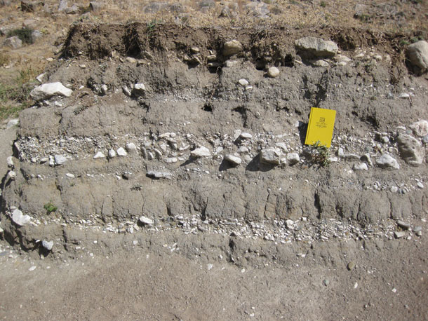
Here’s a bigger version, if that helps.

Another image from Turkey… Tell me, fluvial folks and sedimentary soothsayers, what do you see here?
Here’s a bigger version, if that helps.
Gotta admit this confuses me; would be nice to have a setting; and I assume modern/recent and in an active floodplain? Flow orientation?
Yes and yes — modern, recent in an active floodplain. Flow is to the west, if memory serves.
This kind of sequence forms in a braided stream with a heavy sediment load. The coarse material was deposited in a stream channel. As the stream works new channels, the old channels are buried by finer sediments when the valley floods.
Right. Thanks, John. I was hoping there might be more than that — secrets only visible to those who wear fluvial-colored glasses.
🙂
Well, how about pebble imbrication? To my eye, that lower coarse layer seems to have a number of elongate pebbles with their high ends to the left, low ends to the right, suggesting flow from right to left (is this what you mean by “flow is to the west”? We don’t know which direction the camera is looking). The middle layer, with the notebook, not so much: the pebbles/cobbles are pretty random-looking, perhaps indicating that flow was “into” or “out of” the plane of the image. Shifting flow directions in different beds would also be characteristic of a braided stream with the channel weaving back and forth along the flood plain.
Good stuff. Thanks for pointing it out!
As for your question, I only meant that… flow is to the west. It’s true that the camera is facing north, so west is left in this field of view. But I was only trying to answer Steve’s question up above.
Something else that occurred to me is the degree of rounding of many of the coarse clasts, which speaks to a fluvial environment—as opposed to, say, small debris flow beds near the foot of a mountain, which might have more angular clasts. Of course, this is far from diagnostic, because a debris flow could include reworked fluvial clasts; likewise, fluvial settings are obviously not the only source of rounded clasts. But the observations are at least consistent with the braided stream model.
Another thing: it’s hard to tell from the photo, but most of the clasts also seem to be of a very similar lithology; at least the monotonous off-white color is suggestive of this. If true, it might suggest proximity of these beds to the source, and/or a relatively restricted size of the depositional basin; a larger basin or more distant source would likely mean clasts sourced from a wider variety of lithologies. It could even be used as an indicator of flow direction if, for example, an extensively exposed formation of, say, off-white limestone or quartzite (or whatever that stuff is) was known to occur to the east, whereas other (darker) rock types occurred to the west. This would be useful even in the absence of other flow indicators.
I love gravel pits–the more you look at them, the more you see–they’re way more than just random dumps of rocks and sand! I’m glad you took the photo!
Thanks for the follow-up, Howard.
One item: this isn’t a gravel pit. It’s a natural exposure made in the cutbank of the same stream which deposited the gravel and sand.
Hi,
These are sediments , that are deposit in the flood plain of a temporary, smal river or creek. There is periodicity of a dry sezon and probably winter maximun of rainfall. The degree of rounding of the gravel is not very high so probably the transported distance is not great. The fine(sand) layers are deluvium (there is presence of not rounded sharp edged smal grains in side) formed between the periods of high discharge. On the top there is a shallow soil.