
Sunday morning, I was pleased to join a group of George Mason University “GeoClub” students on a field trip to Thoroughfare Gap, just west of Haymarket, Virginia. It’s a distinctive landmark where westbound travelers on I-66 leave the Culpeper Basin (Triassic to Jurassic rift valley associated with the breakup of Pangea) and enter the Blue Ridge province (Mesoproterozoic basement complex topped with sediments, flood basalts, and a transgressive sedimentary sequence, all metamorphosed and arched upwards and thrust to the west during the Alleghanian Orogeny). One NOVA student, who’s doing an Honors project on this area, joined us as well:
Here’s a view to the south, looking into the water gap:
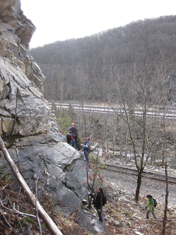
On your left in the above picture, you see cliffs of resistant quartzite. This is the Weverton Formation, a Cambrian-aged quartz sandstone deposit (base of the transgressive Chilhowee Group) which was subsequently metamorphosed during Appalachian mountain-building. Across the gap, you can see the ridge on the other side. This northeast-trending ridgeline is known in Virginia as Bull Run Mountain. It is the eastern limb of a vast anticlinorium (upwarped fold) which is exposed as the Blue Ridge geologic province. The water gap itself was carved by Broad Run (not Bull Run), and you can see the stream itself is not the only linear feature which crosses Bull Run Mountain at this latitude. You can also see the train tracks, Interstate 66 (both east and west-bound lanes) and in the far distance, Route 55.
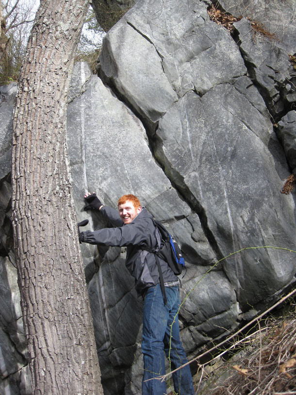
We came here to check out the rocks. Students Aaron and Alan had scouted it out several weeks previously, and found enough cool stuff that they felt it would make a good site for the GeoClub to check out. They were our trip leaders. Aaron hustled over to the first good outcrop, joined by Tiffany:
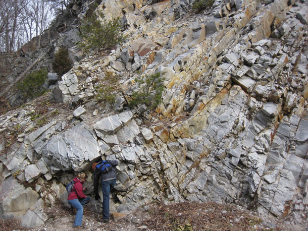
Looking in closer at what they are closely looking at:
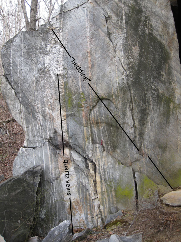
And the annotated version:
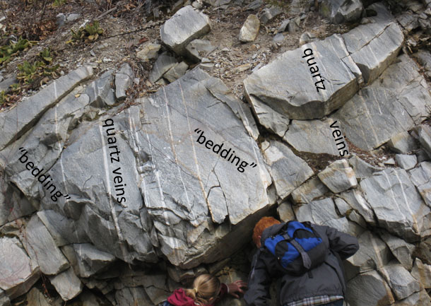
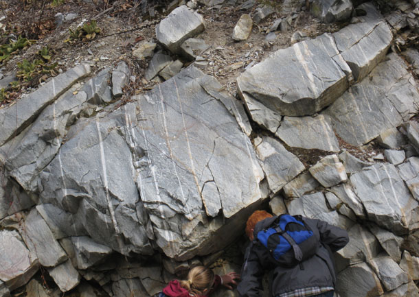
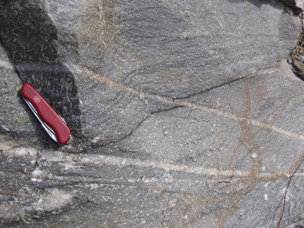
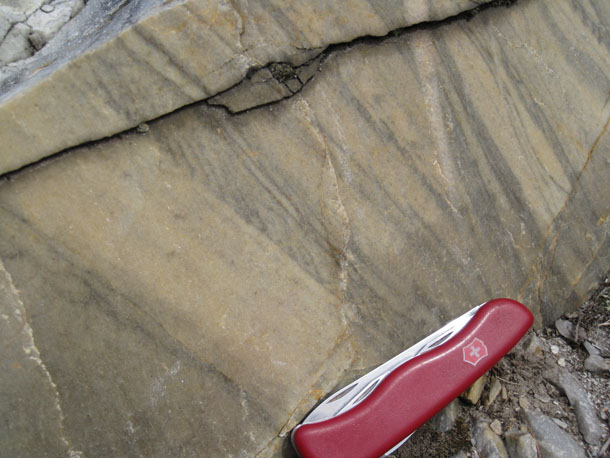
The quartzite here has dark layers in it that we interpreted as bedding. Because of some weird features in it (which I will show you later in this post), I’m not 100% confident in my “bedding” interpretation, but let’s go with it for the moment, and just put “bedding” in quotes to indicate our lack of certainty. (Deal?) If I’m right about it being bedding, then clay flakes originally deposited as layers within the sandy facies of the Iapetan shore were locked in place during lithification and ensuing metamorphic fusing of the quartz grains around it. Later, this bedding was tilted to its current orientation, dipping moderately to the east. At some other post-depositional point (but not necessarily before or after), the quartzite fractured, and hot water sealed shut the fractures with a series of white-colored veins of milky quartz. These quartz veins are subparallel to one another, and dip steeply to the east.
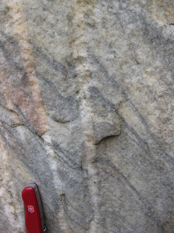
Where we observe the cross-cutting relationship between the quartz veins and the “bedding” planes on certain outcrop surfaces, we can detect offsets in the bedding, like the prominent black layers in this photo:
You can see the apparent offset here is “left lateral,” …
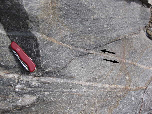
… but when you actually orient this photograph on the outcrop, the west side of the quartz vein is dropping down relative to the east side — a “normal” offset (in the faulting sense of the word).
Aaron found an exposure further up the hill where a creep-tilted tree was parallel to the quartz veins. Coincidence?
(Yes, it’s coincidence.)
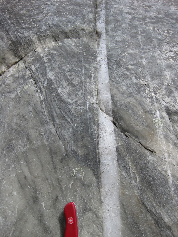
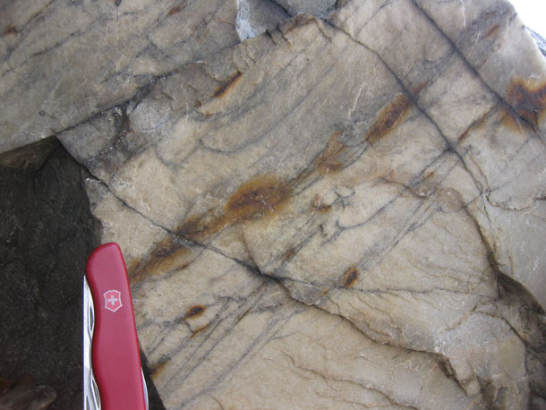
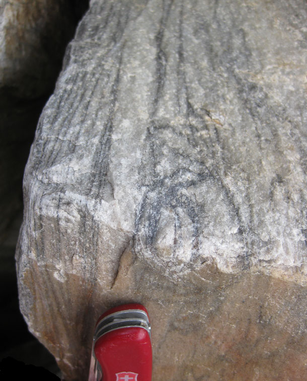
Another exposure showing the relationship between the veins and the “beds:”
Perspective is towards the north. My trusty Swiss Army knife (at center) provides a sense of scale. Here’s an annotated version of the same photo:
If you zoom in to the exposures at the far right of this outcrop, you’ll see this:
The “bedding” here is deflected along the quartz vein in what appears to be a drag fold. Again, the sense of kinematics is west-side-down, and east-side-up. Here’s another:
Okay, had enough milky quartz veins? Let’s go back to the question of whether these black layers are really bedding, and associated primary sedimentary structures.
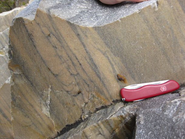
Here’s a scene that looked to me like lovely, classic cross-bedding, concave-up indicating paleo-up (which is also current “up”):
But here’s another spot, not too far away, where the truncated side of the “cross beds” faces the other direction! They are concave-down, which indicates the younging direction (paleo-“up”) is in the direction that in the modern day we would call “down”:
… Okay… so maybe it’s not just a giant slab of sandstone fused into quartzite and preserving all its internal structures intact, like a mammoth frozen in tundra. Perhaps there is some internal folding which has flipped the bedding around in some kind of isoclinal fold (the black layers are parallel regardless which way these “crossbeds” indicate is “up”).
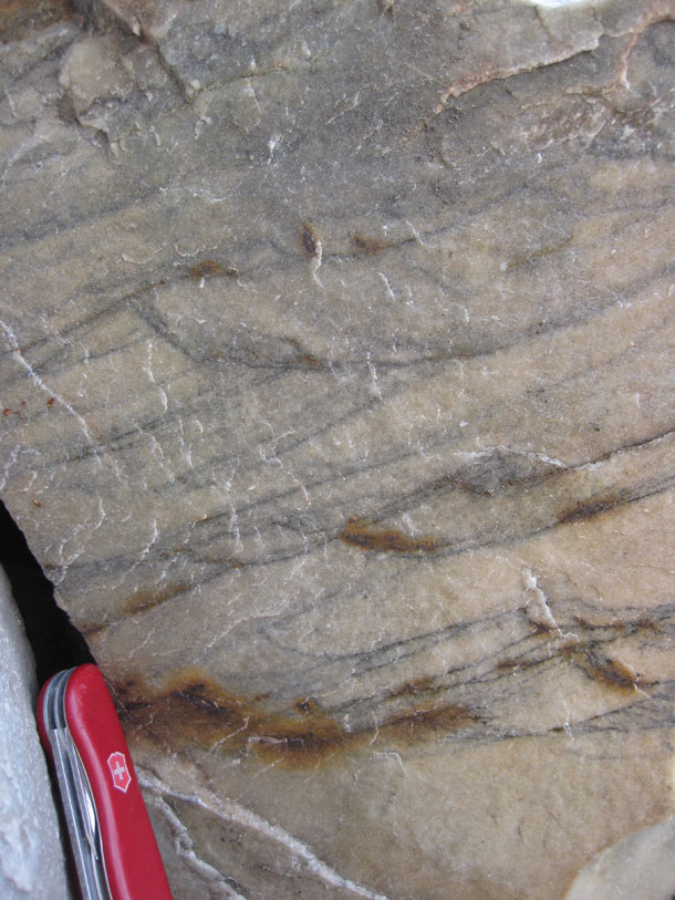
But what do I make of this…?
Okay… that looks something like cross-bedding, but it’s pretty crisp and steep there on the edges. If these black layers are clay highlighting scours into earlier-deposited sand, then how come they curl over on themselves? Were the originally deposited at the angle of repose and then later deformed? What’s driving me nuts about interpreting these structures is that they can’t be undeformed cross beds, as those have an angle (with respect to the main bed) of 30° or so. These suckers instead curl up past 90°, and even tilt back on themselves!
And what about this…?
What is that? Are these deformed crossbeds? (i.e., the top of the cross beds have been sheared in the same direction the current was flowing) Or is this the lining of some burrow? Is this a trace fossil?
Really, this pattern reminds me of “ladder dikes,” and those are primary magmatic structures, not the sorts of things you would expect in a batch of Cambrian beach sand… Maybe some sort of dewatering or gas escape structure? Your hypotheses (and justifications) are welcome! (That’s what the comments are for.)
One more… A different section through what might be the same thing as the previous image:
Right there on the corner — a series of nested and partially overlapping (cross-cutting) circles:
Again, I find myself thinking of “snail structures,” magmatic primary structures which are thought to reflect flow through a tube-like “pipe” going up through the crystal mush of a magma chamber, though sectioned “horizontally” rather than the vertical section which we call a “ladder dike.” Clearly, this isn’t an intrusive igneous rock, but there was potentially something dynamically similar at work on these rocks.
Thoughts as to what these patterns are, or how they formed? I’m grateful for your feedback.
I’ll continue with describing what we saw on this field trip in a future post. That’s enough for today.
Soft-sediment deformation or dewatering structures? Just a quick thought, but I’d want to see some more cross-sectional detail to feel comfortable with that. Liesegang banding? Or do the darker colors represent a sedimentary texture change? How much has the metamorphism affected the parent textures?
Matt, thanks for your thoughts. Dewatering structures that I am familiar with are oriented ~perpendicular to bedding, and these suckers are parallel to “bedding.” As for Liesegang banding, the dark layers appear rusty in some spots, but mostly they just appear dark gray. I can’t see any sedimentary texture change, as the rocks have been completely fused by metamorphism — all that’s left at the meso-scale is color changes. Doubtless a few thin sections would be very instructive…
Funny that Matt should say soft sediment deformation. I show the DVD “The 275 Million Year Story of Captiol Reef” to my Earth science students every year (it’s a great introductory video to show because it covers a little bit of everything). One of the features that they describe is called the “Elf Slipper” and is an example of soft sediment deformation. They do a great job of explaining how soft sediment deformation works. Anyway, as I was looking at these pictures, I was immediately reminded of this DVD and the examples of soft sediment deformation, so that’s my vote.
BTW – Here’s the DVD for any other teachers that might be interested – http://www.capitolreefnha.org/product.cfm?id=AD0B8572-3048-7C56-5FD5AB37086AC39A
Cool name, “elf slipper” — Can you share a little bit about how it forms?
I’ll keep searching for a picture, but in the mean time, here’s the gist of what happened. Imagine there’s a sand dune that might have a little clay mixed in with the sand. I rains. Some of the sand slides down the slip-face of the dune as sort of a slab because of the water and clay. The slab slides down and the leading edge butts up against something. The force of the impact causes the leading edge to curl around (like toe of an elf slipper). The feature is then buried and preserved for the enjoyment of future geologists.
This isn’t the Elf Slipper, but it’s a great example of soft sediment deformation at Capitol Reef so you’ll hopefully get the idea… http://www.sed.utah.edu/Stop2_4.htm
Interesting. I can visualize that. Two thoughts: (1) the Weverton was not deposited in an aeolian environment like the example you link to (just so we are clear that it is interpreted as marine), and (2) I think a big difference between what you describe and what we observed is that our mystery structures are quite small scale (only a few cm in extent) and are bracketed above and below by beds which show no such evidence of soft sediment deformation, not even slight perturbations…
Not dismissing your idea; but those are a couple of complicating factors that occur to me.
I figured they were too small, but the shape of the beds reminded me of the structures I mentioned.
And hey, considering I only have a BS in geology and haven’t really “done” geology in over 10 years, I’m just happy I had something pseudo-intelligent to add to the conversation. Your blog is has been a great refresher for me. Didn’t think I was being dismissed at all! Not the first, nor the last, time I interpreted geology incorrectly.
Here is a much smaller scale of soft sed deformation. Again, it occurs in eolian rocks, but I can picture similar slumps occurring in marine rocks as well. Photos 1-3 http://eas.unl.edu/~dloope/NavajoSlumpsWeb/NavajoSlumps.html
Nice! Thanks, Mel!
Hi Callan, I’m doing my honours project on a Cambrian aged shear zone and couldn’t help but notice that in one of your pics (13th from the top I think), the wrong way up “younging” looks more like a disharmonic fold with its limbs sheared. I can see a bunch of other sinistral movement indicators too and am wondering if these structures are not primary but are in fact tectonic and the banding which has been deformed is a result of mylonitic recrystallisation. Can’t quite put my finger on it but something in the photo below (“But what do I make of this…?”) says boudinage to me although similar structures in the other pics make me doubt this. Is there other evidence for a large ductile shear zone in the area?
Depends on what you mean by “the area” — not that I know of right at Thoroughfare Gap, although there are multiple anastomosing Paleozoic (Alleghanian?) high-strain zones that criss-cross the basement complex west of T.Gap. The sequence at T.Gap is relatively coherent, with Catoctin Formation below these rocks, and shaley “Harpers Formation” above.