
A new resource for the Japanese earthquake is online this morning, a “supersite” similar to the ones that exist for other huge events. Checking it out this morning, I found some interesting stuff. Over night, there have been more aftershocks, and here’s the most recent 600 or so events in the area, taken from IRIS’s interactive map. You can see the big circle that represents yesterday’s main shock:
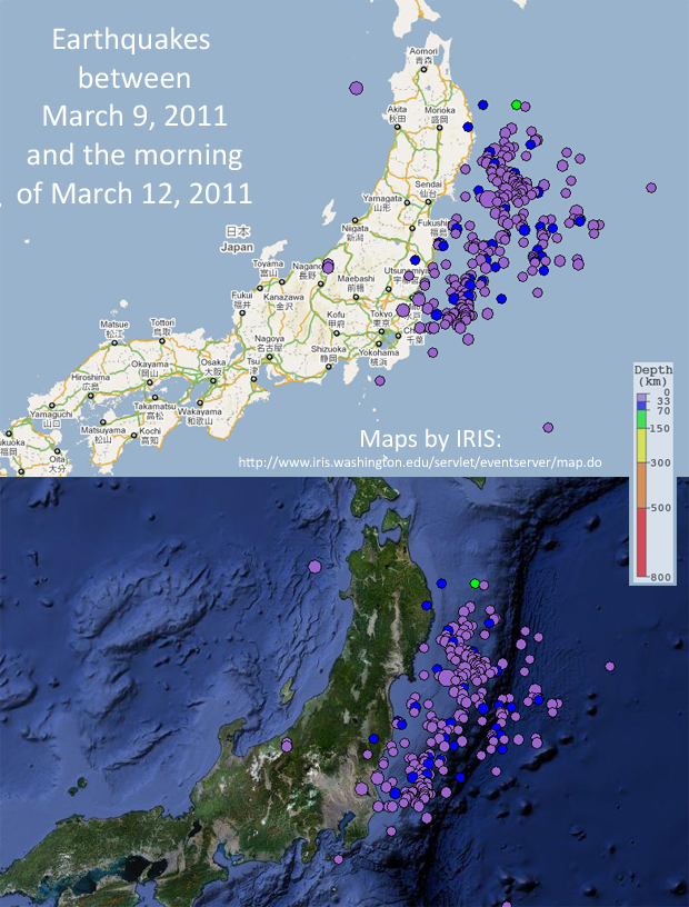
Explore the IRIS Earthquake Browser yourself by clicking here.
Also of note is this GPS vector map — this shows with arrows of different sizes and orientations the motion vectors of different spots on Honshu as a result of the event, its foreshocks, and its aftershocks:
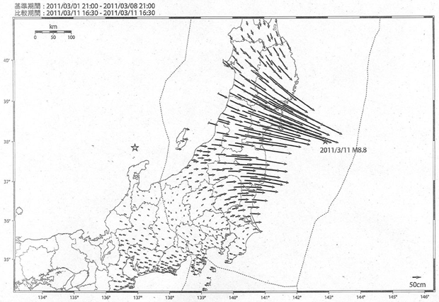
Basically, this is a comparison (as the upper left indicates) between March 8 at 9pm and March 11 at 4:30pm of the positions of a bunch of GPS receivers. They’ve moved, some more than others. It’s from information like this that we hear news reports about how the “coast of Japan has moved 8 feet to the east.” Note the scale bar in the lower right is 50 cm. Though there is some overlap that makes the arrows appear to designate greater magnitudes than they really do (poor information design, I’m afraid), some of the lone, clear arrows clearly indicate displacements of more than 2 meters (4 x 50 cm).
A few other links that may be of interest:
Chris Rowan of Highly Allochthonous discusses the tectonics in a much-anticipated post here.
Steve Schimmrich of Hudson Valley Geologist examines the idea of next week’s “SuperMoon” perigee-syzygy, and dismisses it as having anything to do with the quake. (Neil DeGrasse Tyson made the same point yesterday, but Steve goes into a revealing level of detail. Check it out.)
Meanwhile, in Japan’s city of Fukushima, a nuclear power plant is exhibiting some scary symptoms of melting down, including release of cesium and iodine, and exploding. As Evelyn of Georneys said on Facebook last night, paraphrasing my “flaming tsunami” remarks from yesterday, “The only thing worse than a tsunami on fire is a nuclear power plant + a tsunami on fire.” We all wait to see what will come of this horrific example of a bad situation –really, really bad– going to much, much worse. I’m comforted by reports at posting time that the reactor itself wasn’t harmed in the explosion, though that strains credulity. Hoping for the best there. Stay tuned.
Wow. That GPS map is amazing (and broadly consistent with the slip models showing the most slip in the north-central part of the rupture). That one’s going to come to class on Monday.
Hey, Callan. Thanks for your wonderful summary and insight. I found your blog via link on Skepchick, and I happen to be somewhat related to you (by marriage). I’m so thrilled to have found your blog! I’ll be adding you to my RSS feed stat.
Katy: what’s the marriage link? (Who?) -C.
I’m Karyn’s younger sister. 🙂
Oh! that Katy! Good to see you here! How you doin’?
I’m great. I sent you a FB email so I don’t post all over your blog. 🙂
If I ever had a single ounce of belief that nuclear power could be safe, this event has certainly wiped that all away. We can provide assurance by building better containment structures, or more reliable back up generators to cool the plants if they fail, but I really doubt our ability to always overcome the awesome power of the planet and its phenomena.
There are nuclear reactor designs that do not involve water-based cooling systems and therefore have very different levels of requirements for safety. See the comparison at http://www.hyperionpowergeneration.com/learn-ler-smr.html
This is wonderful, the information you provided! I really enjoy the GEO Geohazards Supersite on the Sendai. Compare the pre-seismic interplate coupling 2001-2011 with foreshocks-mainshock and aftershocks and coseismic displacement (slip). I am very interested in how this began with foreshocks. I live in Brookings-Harbor, OR. Our boat basin docks and damaged boats are being repaired after tsunami surges caused destruction. If Cascadia start getting foreshocks similar to Honshu along the Oregon Coast, offshore Brookings-Gold Beach-Port Orford, that would be the beginning before the Great Subduction Earthquake, such as a M 8.9 we might get with a big coseismic slip patch with displacement to send a tsunami to Japan, and all the aftershocks with slip continuing. Thank you very much for your Mountain Beltway AGU Blogosphere. After what happened in Chile and now Japan, researchers are learning more about it.
Please forgive my complete lack of knowledge (but not lack of interest…:-)), but isn’t the more interesting thing going on where the GPSs have moved in the OTHER direction? ie. it looks as if someone (God probably) put his fingers on the far side of the island, his thumbs near the point of ‘no motion’ and then pulled his fingers towards his thumbs. especially since the epicenter is farther up where the most movement was towards the east. would more pressure be building at the ‘point of the thumbs’? or is under that point where the separate plates have a ‘changeover to the other plate’?
It’s an interesting observation, and I’m not sure what to tell you about its cause — except that the “God’s thumbs” explanation only works as an analogy — asking how big God’s thumbs are strikes me as a similar notion to the question of how many angels can fit on the head of a pin.
One thing you may consider: this diagram shows the changes in GPS positions over almost three full days. It’s not a representation of instantaneous motion at the time of the big 8.9 magnitude quake on Friday. So the GPS receivers in the southwest may have been moved by foreshocks or aftershocks, or by unrelated quakes, or something else entirely. Anyone else want to chime in here with insights?
Oh wait — I got it, or at least I’ve had another insight. After looking in detail at the image, I realized the GPS recievers you are noticing are on a different tectonic plate, which would act as a relatively independent block. As the North American Plate slides to the east, the Eurasian Plate doesn’t necessarily have to go with it…
One other possibility: The southwestern GPS units may be recording the westward tracking of unslipped land, which moved “with” the Pacific Plate (i.e., to the west) rather than slipping east with the North American Plate. Consider that with this 30 second YouTube video.
Hi Callan,
Great information as usual.. Would this movement to the east by the plate that Japan is on, sort of put to rest finally the contrarian ideas of the expanding Earth proponents? It seems obvious now that subduction has taken place on a huge scale.
Thanks.
That’s a great idea — we just need GPS units mounted to the oceanic crust!
One item: Japan is not on a single lithospheric plate; parts of three different plates underlie that one country.
From a friend in Japan:
“Horizontal motion:
http://www.facebook.com/l/4d750/www.gsi.go.jp/common/000059033.pdf
Vertical motion:
http://www.facebook.com/l/4d750/www.gsi.go.jp/common/000059037.pdf
Geospatial Information Authority of Japan (GSI)
http://www.facebook.com/l/4d750/www.gsi.go.jp/chibankansi/chikakukansi_tohoku.html“
Great stuff, Barry. Who’s your friend in Japan? I’d like to share these, and to do that I’d love to be able to give credit where it’s due… Thanks again.
My friend is Tatsuki Tsujimori at Okayama University in Misasa (That’s in Western Japan, so they didn’t feel the earthquake). Something else that he pointed out was this map: http://en.wikipedia.org/wiki/File:Power_Grid_of_Japan.PNG
that shows that western Japan uses 60 Hz electricity and northern Japan uses 50 Hz electricity, meaning they can’t share electricity between western and northern Japan, thus intensifying the problems caused by the loss of the nuclear reactors.