
Whilst browsing the planet’s surface for Where on (Google) Earth #279 last week, I found this interesting fold expressed on the surface of Grewingk Glacier, in the Kenai Mountains of south-central Alaska. Check it out [Google Map link]:
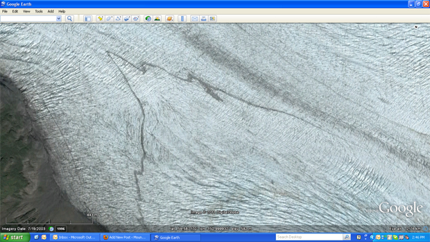
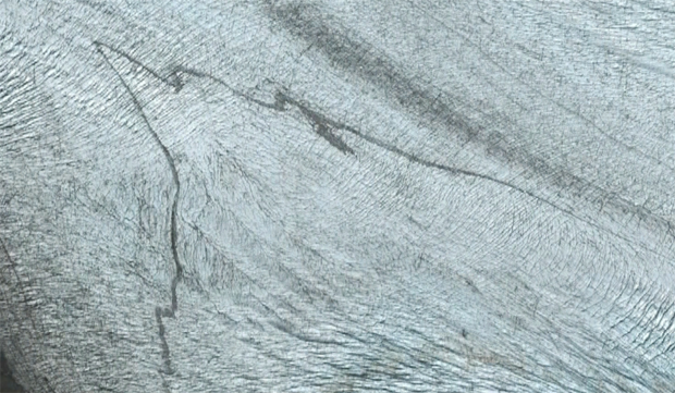
I’m not quite sure what to call this feature. Certainly the “sediment in ice” pattern (dark in light) suggests a medial moraine, but this structure doesn’t meet the textbook definitions of any kind of moraine I know about. It’s certainly not parallel to the glacier like a medial moraine. The overall pattern is perpendicular; perhaps we should dub it a “transverse moraine.” It appears to be a layer of till that has been distorted by glacial flow (downhill is to the northwest). Glaciers, like rivers, tend to have the highest flow velocities in the middle of the glacier, towards the top. A classic demonstration of this fact was performed in the Swiss Alps in the 1870s and 1880s: a series of stakes was driven into the ice in a horizontal line across the Rhône Glacier, and then it was observed how they moved. The ones in the middle moved fastest; the ones at the edges moved slowest. If this odd “transverse moraine” started out the same way, then it could have been distorted by quicker downstream flow in the middle, and less at the edges.
What catches my eye as a structural geologist are the parasitic folds which “decorate” the main fold. Like we saw in the gooily-deformed shales below the Champlain Thrust Fault, parasitic folds are higher-order folds whose asymmetry can be used to infer shearing kinematics on the folded layer:
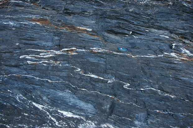
Note the similarity in outcrop pattern to the Grewingk Glacier example…
What do you think of that?
Could be an ash layer in the glacial ice. It would have been originally horizontally deposited, but due to the different flow rates of the glacial ice it now appears to be folded.
I agree with Joel–I think it’s a stratification feature, and the wavy line is essentially the “outcrop” expression on the sloping surface of the glacier. “Down ice” is to the northwest, so this fits. If you zoom in closer, you can see a similar, but fainter feature to the north, symmetrically across the centre of the glacier, on the other side of the medial moraine. As Joel suggests, the source of the “dirt” could be volcanic ash (this is Alaska, after all!); or, looking more closely at those mountains enclosing the glacier, they look awfully dark and shaly: perhaps a big wind storm blew clouds of dust from the bare slopes across and onto the surface of the glacier, where it was subsequently buried under more snow, prior to being exposed as you see it now. Or sumthin’ like that.
It looks like the “fold” cross-cuts the crevasse field with very little deformation–would that imply that it is syngenetic with the crevasses?
I was reading the Fossen Structure book and came upon shear folds–maybe something similar going on here? Here’s an example: http://ic.ucsc.edu/~casey/eart150/Lectures/ShearZones/SheathFoldOT.jpg
I like that idea; and I think it’s plausible. Some data from the third dimension would be nice…This calls for a research expedition!