
My man Walcott contributed a lot of images to the USGS stockpile during his travels. Today, I’ll feature one from Bishop, California, from 1894:
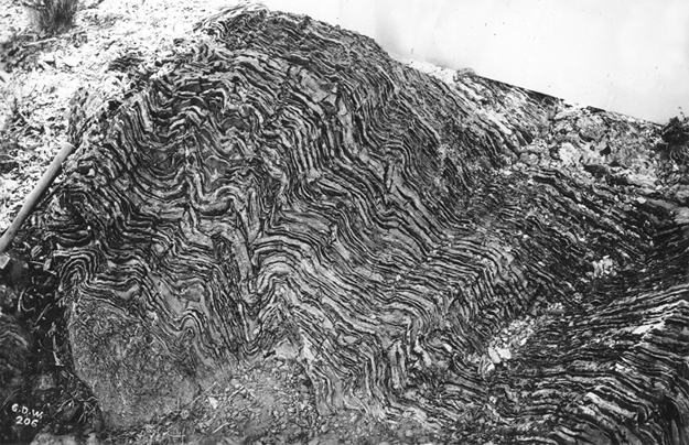
Got it from here. Rock hammer on the left for scale. The caption reads:
Plicated layers of thin bedded chert in limestone etched by erosion, Lower Cambrian (?). Hill two miles west of Big Pine. Inyo County, California. 1894.
This is the one-year anniversary of the Friday fold. 52 weeks gone by, punctuated with lovely folds from around the planet, from me and from others. What do you think of the series? Sick of it? Worth continuing? Valued? Worthless? Let me know what you think. Maybe we’ll be back next week with another…
100% worth continuing! Don’t know how I’d start my Earth Science classes on Fridays without it!
Totally agree with Casey and thanks for the idea I’ll be incorporating this into my Earth Science classes.
I love the Friday fold..please don’t stop
Shame on you for even entertaining the notion of dropping the Friday Fold.
For sure, keep ’em coming! What’s not to like?
I’m bummed out that I wasn’t able to alert you ahead of time of a really cool roadcut of ptygmatically folded lime mudstone (Cambrian) in Kootenay National Park, that you must have driven right past on your way to Floe Lake. If you ever pass that way again (or for lurkers), the Lat/Long coordinates are 50.95981, -115.95572 (NAD 83/WGS 84). You can get a vague picture on GE StreetView. Definitely a must-stop (there’s a small pullout on the highway right next to the roadcut) for any fold fanciers passing through. Hopefully a future Friday Fold!
Oh yeah! That’s a good one!!
Having spent lots of time in Big Pine, I cant believe that the caption on that photo at the link (USGS) is correct. It says two miles west of Big Pine (which is just south of Bishop). I dont recall any such exposures in that area, and the geologic map for the area does not show it either. The only rocks of that type and age are to the east in the Whites. Just wondering, cause its a cool photo.