
On Thursday I posted a photo of an outcrop along Route 49 (Looking Glass Hill Road), north of East Glacier, Montana. I asked you what you thought of it. We had some good comments as a result, of which Howard Allen came the closest to what I wanted to convey.
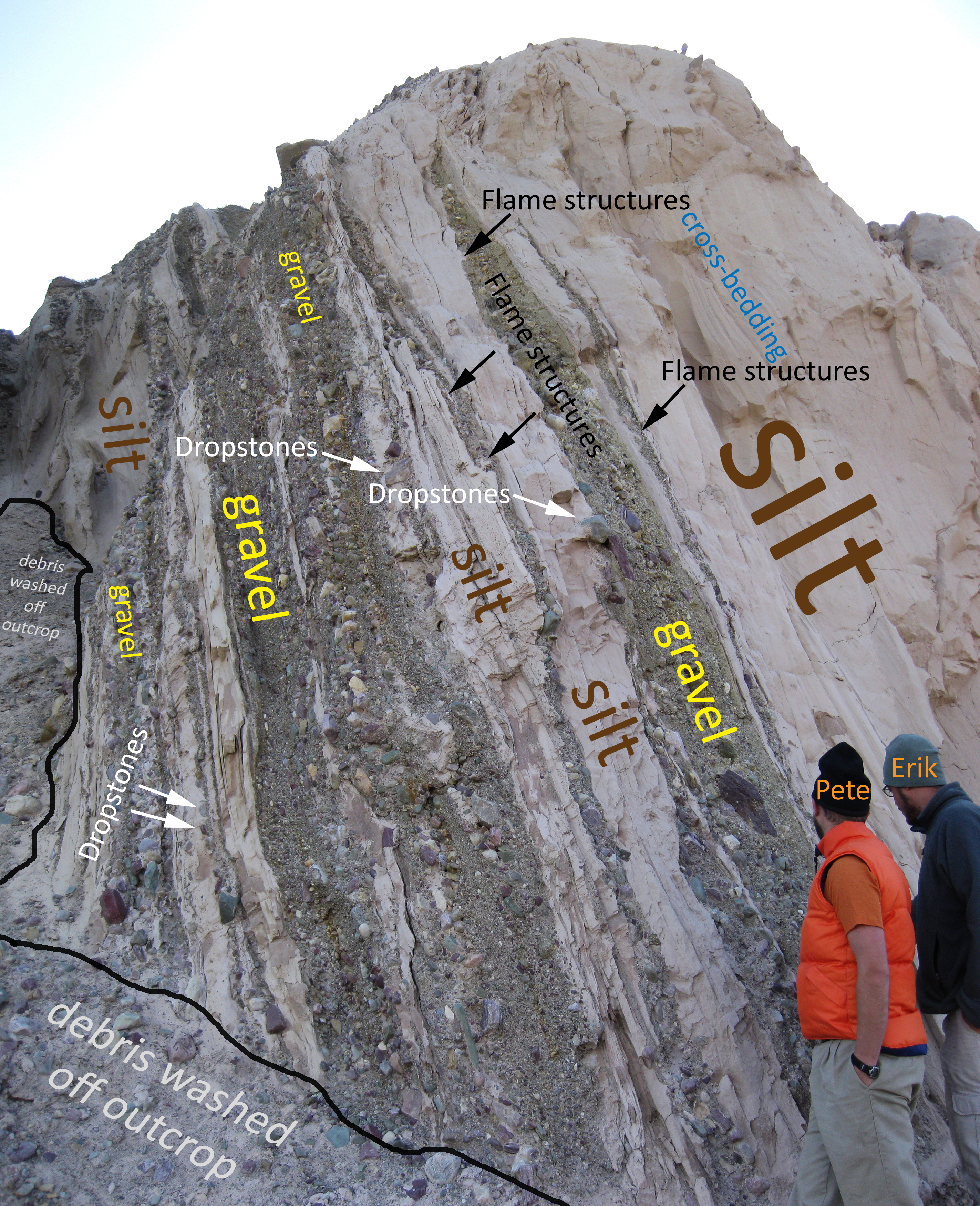
Here’s an annotated version (click through for big version) to illustrate the discussion below:
Here’s what I think happened here:
These are Pleistocene glacial outwash sediments – some of which suggest calm water (lake) conditions, some of which suggest more energetic depositional currents due to their large grain size (pebbles, gravel, cobbles). The source of the sediments is the Rocky Mountains to the west, where Belt Supergroup strata (Mesoproterozoic) are exposed. The most obvious clasts are the red and green argillites. There are some honey-colored limestone clasts in there, too.
I think “up” is to the right, based on the piercing into soft silt by dropstones (as labeled), as well as flame structures pooching up into the gravel layers, and some wide arcuate cross-beds which are concave to the right. I labeled one set. There’s another tangential set of cross beds to the left of the uppermost thick gravel layer, near the top of the outcrop. Again, concave to the right. Having sedimentologists say up is to the left instead worries me, but I’d ask them to take another look. Some of the commenters cued in to the same details that I was noticing. Regardless of my interpretation of primary structures, I feel pretty good about the story I’ve woven from this outcrop. The younging direction isn’t a critical component of my tale. (But I still think it’s to the right.)
Key take-away message:
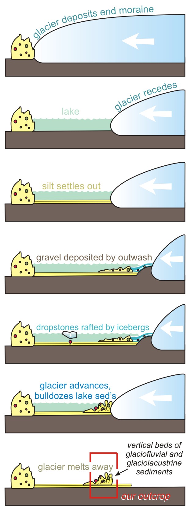
These strata are young, and barely lithified – only to the point of semi-coherence. I broke off big pieces of silt”stone” (crumbly and powdery/gritty to the touch) by hand. Even though they’re crazy young, they’re still bolt upright (regardless of whether up is to the left or to the right). How did they get that way? There hasn’t been an orogeny in western Montana in many tens of millions of years, and certainly not in the past several tens of thousands. So I think what happened is that lake of still water formed on the margin of the glacier, and in those calm waters, these strata were laid down as alternating silt (settling from “glacial milk” suspended in the water column) and gravel (little outwash deltas advancing into the lake, then avulsing elsewhere and dying out). Icebergs floated out other sediment and dropped it in. Perhaps all the gravel is iceberg-rafted debris, in fact, and then I don’t need the deltaic hypothesis at all. Then again, the lens-like pinching out of the gravel strata suggest to me some sort of channel scoured into pre-deposited silt. Anyhow, to go from this original horizontality to the vertical state we find them in now, I imagine that the glacier re-advanced, and nosed into the outwash deposits in front of its snout. Those strata got folded and faulted (in a soft-sediment sort of way) and some of them were pushed to vertical orientations as a result. The glacier was acting like a bulldozer; the sediments behaving like a miniature accretionary wedge. Then the glacier melted away, leaving its sedimentary offspring in this awkward position.
That’s my story. Whaddya think?
Sounds about right to me. I was really vacillating on the stratigraphic “upness” (not that it matters, but it’s a really interesting topic of discussion). For example, some of the clasts you have labelled as dropstones on the gravel-silt contacts I think could go either way. The top of a coarse, freshly deposited gravel bar is not flat–you will obviously have some cobbles that stick up on the surface; if you then inundate that surface with lake waters, those cobbles are going to stick up through the first few layers of silt that get deposited on the lake bottom. Conversely (inversely?), they could be simply “sinkers” (i.e. essentially “load casts”) that are the first few cobbles on the bottom of a gravel bar that have sunk into the soft surface muds of the lake bottom deposit. Or, they could be dropstones, as you say. It’s a tough call.
The features labelled as crossbedding I interpreted as deformation/differential compaction of soft lake-bottom silt, as I wouldn’t ordinarily expect to see large-scale crossbedding in low-energy (essentially still-water) lake bottom sediments.
I definitely agree with your flame-structures of lake silt squirted up into the overlying gravels, and they are the least ambiguous geopetal features I see in the photo.
Definitely a thought-provoking outcrop! Thanks for sharing it.
Glaciotectonics has long been a subdiscipline of glacial geology. Proglacial sediments are commonly faulted, folded, and thrust up during glacier surges and over-riding by ice. The most interesting are Cretaceous blocks of chalk bedrock overlying glacial sediments in the Dakotas and in Denmark. Glacitectonic structures in glacial sediments are widespread in northern North America and northern Europe.
I think your interpretation is on the mark except that it may have occurred well in front, at the terminus, or even underneath the ice margin.
cool picture, would love to see more.
cheers
very interesting post & outcrop; thanks for sharing!
Another take-home point that may be obvious to geologists but not so much to some others working in the environmental field is that glacial terrains don’t often have simple horizontal “layer cake” stratigraphy. Rather, there is sometimes great lateral heterogeneity over short distances.
BTW, I much rather see annotated pictures than paint on outcrops!