
On Tuesday morning, before the earthquake hit, I answered an e-mail about DC faults.
I get unsolicited e-mails all the time (and occasionally phone calls, too). The contact comes from people who have a geological question, find my blog, and figure that I might be willing to answer it for them, or to direct them to someone more knowledgeable. Sometimes they ask me to identify a rock. I see answering these notes and calls as part of my job as an educator and a geological enthusiast. The query I was responding to on Tuesday morning came from a local historian who is writing a mystery novel about D.C.
He wanted to know about two curves in the course of Rock Creek:
There are two sharp bends in Rock Creek: a hairpin turn at the Zoo and a beak-shaped bend near the P Street Bridge. Were these caused by separate earth movements along two adjacent fault lines? Are the bends related to the fall line winding down the Eastern seaboard?
My reply to him, of course, had to be illustrated, and if I make up an illustration for one person, I may as well share it with all. So here’s the map I sent him, and what I said:
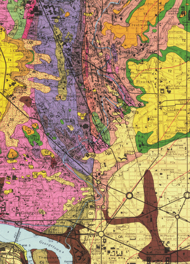
That’s a detail from the Geologic map of the Washington West quadrangle, by Tony Fleming, Avery Drake, and Lucy McCartan. It’s USGS Geologic Quadrangle Map GQ-1748, published in 1994.
One thing that will jump out at you immediately about the map is that the boundary between the metamorphic and igneous rocks of the Piedmont province and the sedimentary strata of the Coastal Plain province winds generally northeast to southwest across the map.
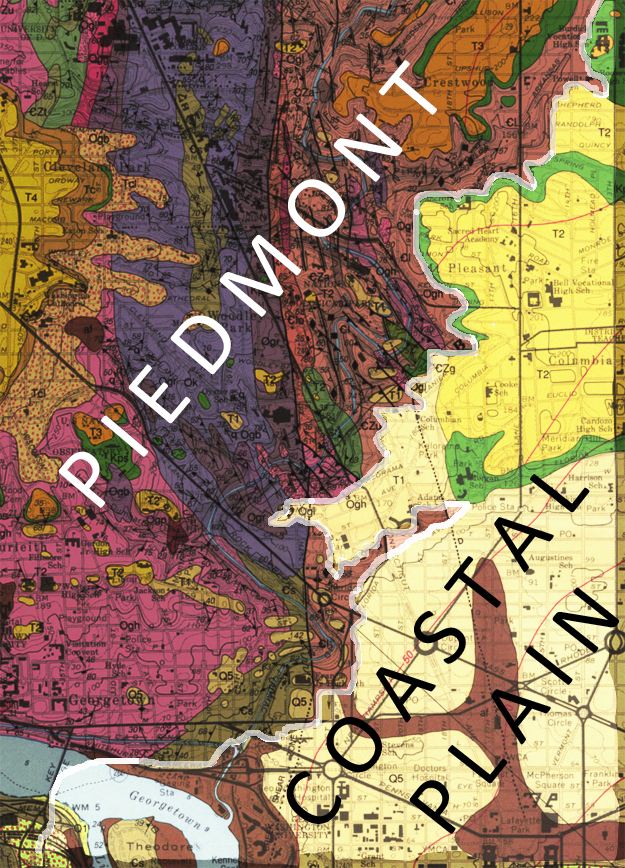
The Coastal Plain sediments are draped atop an eroded surface cut down into the Piedmont. So this contact isn’t a vertical one; it’s closer to horizontal, and dips shallowly to the southeast. The Coastal Plain is wedge-shaped in three dimensions, and this boundary with the Piedmont is its thinnest tip. On a regional scale, this boundary is dubbed the “Fall Line” or the “Fall Zone,” as water flowing in streams over the boundary produces waterfalls where it moves from hard Piedmont into soft, easily-eroded Coastal Plain.
Now the creek bends that my historian correspondent was wondering about are two particular twists on an overall pretty curvy course:
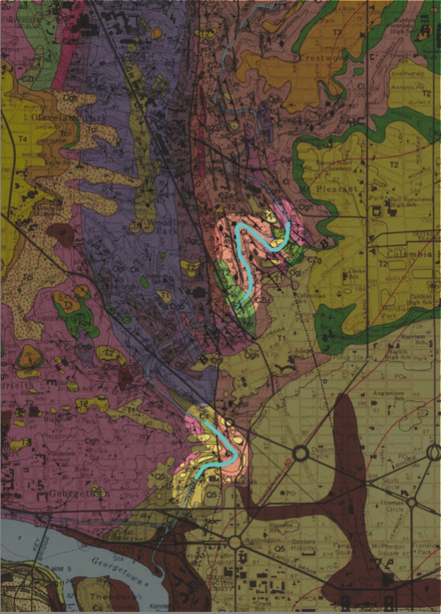
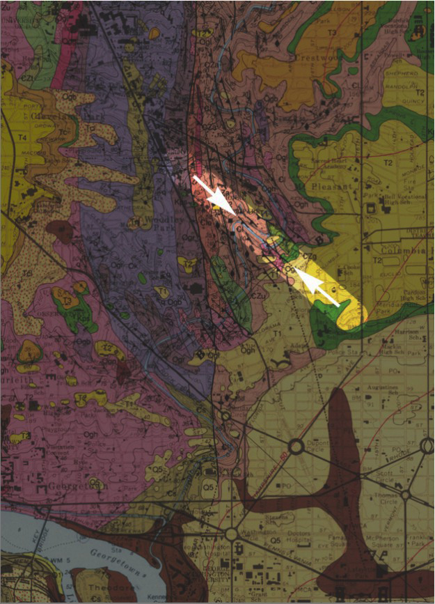
Look at the map for known faults, and you can see that one (or two, really) line up with the upstream end of the upstream creek bend (the one at the Zoo, where the Beach Drive tunnel cuts through the ridge). There is a fault on the northwest of that straight section of creek (near the spectacled bears’ cage in the Zoo), and another (the Darton Fault) exposed on Adams Mill Road at its intersection with Clydesdale Place.
It seems quite plausible to me, the way they all line up in the same orientation and along strike of one another, that they are different expressions of a single fault (between the white arrows here):
But the downstream side of the Zoo “hairpin” turn in Rock Creek shows no evidence of fault control, and neither does the “beak” shaped bend near the P Street Bridge.
The answer to the historian’s other question (about the Fall Line) would be “no” – the faults are small, absent, and/or in the wrong orientation to match the Fall “Line.”
It sounded to me as if he might be conflating these two “f” words into a common model. The Fall Zone has only to do with the difference in erodability between the harder metamorphic and igneous rocks of the Piedmont province as compared to the softer, weak sediments of the Coastal Plain. It does not have anything to do with faults.
Any questions?
I would add that the bend in Rock Creek may be related to the fault zone, where there is a contrast in rock type across the fault and more easily eroded fault material, but it is extremely unlikely that the bend is due to motion on these faults after the formation of the river. Maryland is not like California where there are very large ground motions in recent geologic time.
Hello. i was just doing a google image search for a geological study map i once had of Ecuador. Didn’t find it. Found this page. What a beautiful amazing map. i am not in any way a geologist, but am a painter (artist). Is it possible to purchase the map above in any form? Surely i will not reproduce it. Thank you very much. A very very beautiful image. (the top one, and labeled second one) Sincerely, Carl V
It’s a USGS map; you can buy a copy from them. As noted in the post, the image is a detail from the Geologic map of the Washington West quadrangle, by Tony Fleming, Avery Drake, and Lucy McCartan. It’s USGS Geologic Quadrangle Map GQ-1748, published in 1994.