
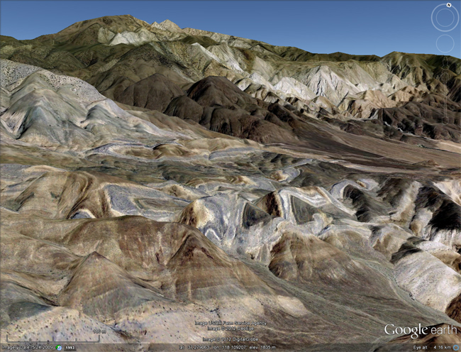
In the White Mountains of eastern California, just west of the Deep Springs Basin (site of my coldest camping experience ever, followed by a memorable morning walk in the playa and discovery of a bat mummified by salt), there lies a classic field mapping location, the Poleta folds. Here’s what it looks like from Google Earth:

And a side-view from Google Earth:

I haven’t personally visited this site, but I found out about it when I was in the Owens Valley two years ago for the excellent Field Forum there. Kurt Frankel, the structural geologist from Georgia Tech who was tragically killed last summer, told me it was a great place to bring students for a fold mapping project. I’m going to be bringing a crew of NOVA students to eastern California for spring break this year, and depending on snow cover, we may attempt to visit the Poleta folds in person, and pay homage.
Just a suggestion for your trip to E. Calif.–your group might enjoy seeing the Alabama Hills, both for their geologic and cultural history. Not only are they a scenic pile of spheroidically weathered boulders, they also have a rich history of being the backdrop to many films, including Gladiator and Iron Man.
I took a geologic field camp from UC Berkeley in June 1968 taught by Clyde Warhaftig in this area. It is used by lots of undergrad geology departments although from the Google Earth info you have posted, you can now do the structural geology from your desktop! In 1968 we couldn’t even look at areal photos until half way through the class. You can clearly see the holds and faults and get the sense of the stratigraphy and folding directions from Google earth. I count three major faults. The large fold that noses out at the left can be verified a a syncline and the folds cut off by the fault are anticlines. These are Lowest Cambrian limestones and shales there is a good Olenelid trilobite locality somewhere off the photo to the south. These same units have been stretched and replaced by the Papoose Flat Pluton in the Inyo Mnts.
I spent 4 weeks camping and mapping the geology of the Poleta Folds in the summer of 1980 for my Summer Field Geology class at UCSB.
Still have my map. Four weeks mapping in UCLA’s 1981 summer field class with Clem Nelson. Great class, great professor.
https://www.cambridge.org/core/services/aop-cambridge-core/content/view/3250BDBA4F2FFD8C84FF56105D4ACCE8/S108933260000228Xa.pdf/clem-nelson-19182004-paleontologist-stratigrapher-and-structural-geologist.pdf