
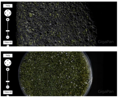
Here’s two new GigaPan images that the M.A.G.I.C.* team has produced (my student Robin R. is responsible for both of these images) of samples I collected a few years ago in Hawai’i. Part of my vision for this collection is to have thematically-connected images that instructors could use to put together online geologic assignments for their students. Consider these two images, for instance. One is of a cobble of porphyritic, vesicular basalt, and the second, of sand collected in a small cove a few feet away.
It seems to me that students could use images like these in an introductory lab assignment on igneous rocks (crystal nucleation and growth, lava eruption and degassing), or in a sedimentary lab, thinking about the relationship between sedimentary characteristics and provenance. The professor could even assign students to make a rough quantification of how much basalt had to be weathered to generate a given volume of this sand. The professor could ask about other sources of particles in the sand, like orange/white shell fragments.
Other themes of connected GigaPans that occur to me:
Appalachian geology or Rocky Mountain geology (location is the theme)
Subduction zone geology, clastic sedimentation geology, karst geology (process is the theme)
Hand-samples, sediment samples, and outcrops from each physiographic province (scale is the theme)
An online sample set for Physical Geology, Historical Geology, Economic Geology, Structural Geology, etc. (an academic program is the theme)
What sorts of themes can you dream up that it would be useful to have gigapixel-resolution imagery for? How can we help you?
____________________________________
* M.A.G.I.C. = Mid-Atlantic Geo-Image Collection
The great thing about gigapan photographs is the ability to see things at various scales, from the roadcut to the hand sample, etc. I’ve been searching for gigapan pics that have something visual to offer at multiple scales, such as geologic structures. Small scale geologic structures give clues about how to better understand large scale structures. Some examples of that in gigapans would be great.
Examples I’d like to find/see:
a large-scale fold with 1) small-scale parasitic folds; or 2) primary sed structures indicating strat facing; or 3) axial planar cleavage; or ??
Ron Schott has already pointed me toward a couple of gigapans that are useful for this type of exercise.
Thanks – that’s useful. Exactly the sort of specific “goal” I can focus on achieving.
Relative age relationships- superposition and cross-cutting.
I just used your gigapan in class about 40 min. ago and it was great! I was lecturing on transportation mechanisms and their various effects on sediment grains. They all had local aeolian sand and with hand lenses compared it to the beach sand in the gigapan. We also compared the olivine sand grains to the x-tals in the host basalt…I’m going to try a few more things with tomorrow’s class using this gigapan and see what else I can come up with…
Wow, that’s great! Thanks for field testing it!
I can’t help thinking what a great tool this would be in oil-industry geology (where I work), especially for trainees learning to examine & interpret drill cuttings, which is a valuable skill not taught in college/university geology programs (AFAIK). Being able to virtually scan around a tray of cuttings and zoom in to see examples of the myriad rock properties that need to be interpreted (lithology, sorting, porosity, porosity types, grain relief, cements, oil stains, fossil fragments, accessory minerals, cavings, contaminants, etc., etc.) would be a great learning tool.
It would be even better if there was an x-y coordinate indexing system available (“see well-developed quartz overgrowths at x = 1178, y = 943”).
It’s no x-y coordinate indexing system, but you can use snapshots to bring attention to specific details. Here’s a link to the original image of the porpyhritic basalt Callan embedded in this post:
http://gigapan.org/gigapans/98984
Below the image are four smaller images. Click on one, and it takes you right to that spot in the main image. Anyone with a gigapan.org account can add snapshots to an image.
Howard and Robin – We have the potential to develop some new viewers for GigaPans, with possibilities like:
a) adding annotation (with the capacity to make it transparent if need be)
b) adding a coordinate/reference system
c) adding measurement capabilities
I like the X/Y idea – but for now, snapshots get us most of the way there.
Here’s some examples of a similar notion, the “comparative viewer”:
http://gigamacro.com/gigamacro-gigapixel-comparative-viewer/
Robin and Callan– Yes, it looks like there’s already an amazing set of tools available out there, waiting to be pulled together and exploited for education. The layered “GigaMacro” examples make me think “thin sections!”: plane polarized on one layer, crossed nichols on another. (I’m probably not the first one to think of this!)
The idea of xpl next to ppl is a great one. I just might make one of those to see how it does! Only problem is loss of being able to rotate a sample, but nonetheless a lot of possibilities with that.