
Last Saturday, my former/current student Alan Pitts led a field trip to examine the interface between the western Blue Ridge and eastern Valley & Ridge provinces in northern Virginia. He’s gained a lot of experience with this boundary between two physiographic provinces based on a large number of field days this semester – both GigaPanning for the MAGIC project and volunteering with Dan Doctor of the USGS, who’s working on mapping in the area. The boundary is traditionally interpreted as the trace of a thrust fault:

The idea is that during the late Paleozoic (Pennsylvanian/Permian) Alleghanian Orogeny, ancestral Africa slowly collided with ancestral North America, it deformed the rocks along the eastern seaboard. It was this large continent-continent collision that wrinkled the strata of the Valley & Ridge, but also broke off a piece of the North American crust, and shoved it up and to the west over younger strata (the Valley & Ridge layers). But that story seems iffy in some locations, due to there being no missing stratigraphic section along the contact. So is there really sufficient offset to call it a thrust fault? On the other hand, there are unambiguous zones of highly brecciated rock, and some geologists have interpreted these as fault breccias. Let’s take a look at some of the rocks we saw out there. The main rock until we spent most of the day in was the Antietam Formation, a quartz sandstone (or is it a quartzite?) with characteristic Skolithos trace fossils. Here’s a small Skolithos neighborhood, viewed perpendicular to the bedding plane (i.e., photo’s line of sight is parallel to the paleo-vertical cylindrical columns)’:

And here’s a first look at the brecciated Antietam quartzite, with manganese (and iron) oxides acting as the matrix holding the clasts (the cement):


These breccia cements have historically been mined in Virginia as a source of manganese.

My eye was drawn to some apparent stretching lineation (or maybe simply an oblate fabric imparted by pressure solution: I didn’t have the 3D resolution to distinguish the two) in the clasts, and in many clasts it was still aligned (parallel to other clasts’ lineations) even after the individual clasts had been separated by brecciation:


Our second stop showcased a less matrixy breccia – a sort of “crackle breccia” where the Antietam was seriously fractured, but not so deformed for the clasts to be dismembered or strung out:


There’s not much room for matrix in this situation – whether manganese oxide or quartz (both are common cements in this Blue Ridge front breccias):


…But there are some pockets where dilation allowed the emplacement of manganese oxide deposits:


Interestingly, we also saw these same black oxides that had permeated into the pore space of sandstone, and now were weathering out in positive relief.

Here’s another example:

This one caught my eye as a structural geologist, since the pyrolusite blobs seemed to have an en echelon arrangement towards the right. Let’s zoom in on that area, to examine it in more detail:

This implies, perhaps, some tensional fractures opening up along a little shear zone, and the Mn-bearing fluids flowing through those parallel fractures before oozing out into the surrounding sandstone pore space:

Our last stop, on Calmes Neck (a neck of land surrounded by an incised meander of the Shenandoah River), we saw the Waynesboro Formation (stratigraphically, the Waynesboro is above the Antietam), and it exhibited a very different style of deformation:

What you’re seeing here is a pattern of asymmetric, anastomosing cleavage known as S-C fabric.


This particular pattern (with the S’s peeling over to the left) is the sort of thing that can be produced by top-to-the-left transpressional shearing.

The perspective in these photographs is looking from the south towards the north, so you’re seeing the kinematic signature of the east moving up and over the west (which is what you would expect from weaker carbonate and clay-dominated strata immediately below the Blue Ridge Thrust Fault):


This stuff looks very much like a lighter-colored version of the sheared-up shale underneath the Champlain Thrust Fault in Vermont. I’ve seen similar sigmoidal domains bounded by highly-cleaved rock in Cretaceous shales beneath the Home Thrust in the Sevier fold-&-thrust belt of western Montana, and even in sheared-out greenstone of the Catoctin Formation in Shenandoah National Park. This was another lovely example of the anastamosing cleavages that phyllosilicate-rich rocks can attain when they are subjected to transpressional stresses.


So that fits into the bigger picture perhaps something like this (blue is Waynesboro limy shale; yellow is Antietam quartz sandstone / quartzite):

It was an enlightening day in the field, and as a result of seeing these rocks and thinking about them, I’m now more skeptical about the true nature of the Blue Ridge Thrust Fault, if indeed it even exists… I’m grateful to Alan for leading the trip.
That’s an odd juxtaposition of deformation styles because it would actually suggest that the fault was a normal detachment fault, not a thrust. In a thrust fault setting, you would expect more distributed (in some cases, ductile) deformation in the hanging wall because you are bringing hotter (presumably more plastic) rocks up and putting them on top of cooler (brittle) rocks. In the detachment fault case, you exhume hotter rocks in the footwall and place them next to the cooler rocks of the hanging wall. Now, of course, this all assumes that you have enough fault displacement to see rocks from either side of the brittle-ductile transition.
The other explanation being that the different units have competencies and thus have different deformational styles at identical deformation conditions.
Yeah, it is odd. I think it’s a competence contrast. It would certainly revolutionize Virginia geology to reinterpret the Blue Ridge / Valley & Ridge contact as a detachment fault! If you look at the Champlain Thrust or other similar exposures, the difference in deformational style is extreme despite similar temperatures and pressures.
Hi Callan,
To help aid the structural interpretation of this interesting area, take a look at the Frederick 100K sheet (Southworth and others, 2007), or jump to the map.
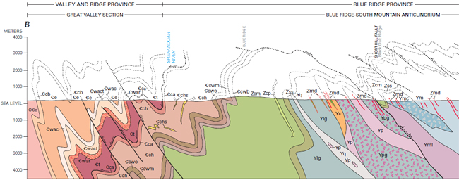
The western edge of cross section B-B’ shows how the thrusting of the Blue Ridge rocks against the younger Paleozoic strata–so obvious further south in Virginia–is more complicated to the north, where strain is accommodated by a series of en echelon transpressive oblique thrusts, cutting earlier formed folds. Rather than fault-propagation folds, these appear more like fold-propagation faults (do those even exist?)!
Note that there is an earlier (pre-Alleghanian) detachment fault shown just above the contact between the Antietam and Tomstown formations, which is interpreted to be highly folded by Alleghanian deformation. Evidence for this is a thin mylonite zone within the Tomstown (the existence of which Alan can attest to).
In spite of all the previous mapping, the brecciated quartzites are still an enigma worth working out.
Here’s a screenshot of the portion of the cross section that Dan is referring to:
Dan,
Thanks for the link! It’s been too long since I looked at this map. It’s a good one.
As for the “mylonite” which implies a detachment, I went and looked at that in the field with Alan that same day, just north of Watermelon Park, and found myself less than impressed by it. Maybe a thin section view would convince me that fabric was mylonitic, but the outcrop didn’t suggest mylonitization to me. Or maybe I just need to see more “unmylonitized” Tomstown in the field.
Is there any offset along this purported detachment?
C
Article could use a horizontal topographic map and a surface geology map with the surface fault identified.