A geological cross-section through my new commute. Click to enlarge.
Now that I live in the Fort Valley, I have a new commute. Every morning that I drive into my office at NOVA, I make a transect across Virginia’s main physiographic provinces. It should be noted that by “every morning that I drive into my office,” it should be understood that I mean “about once a week.” Though this commute is significantly longer than my old DC-to-NOVA run (about 75 miles as compared to 22 miles previously), I’ll be making it less frequently. In fact, my total number of hours on the road each week will be going down by about two hours (from 5 to 3). My new commute offers plenty of reflection on Virginia’s geology. Let me tell you a little bit about it.
The first 20 minutes of my new commute are spent in the folded Paleozoic strata of the Valley & Ridge province.
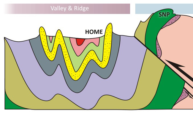
I drive along strike for about ten minutes, following the axis of the Massanutten Synclinorium, going from the Needmore and the Mahantango down through the Helderberg and the Massanutten Sandstone and into the Martinsburg. At Waterlick, I turn right and drive across strike to the east for another ten. I cross the Martinsburg and some of the carbonate formations: the Edinburg, the Lincolnshire, the New Market, the Beekmantown, the Conococheague. Collectively, all these strata were deposited under both passive and active margin sedimentary conditions during the Cambrian, Ordovician, Silurian, and Devonian periods of geologic time. The carbonates (in two packages, one Cambro-Ordovician, and another thinner set from the early to mid-Devonian) record Bahamas-like conditions, while the clastic sediments occur in pulses correlated to episodes of mountain-building further east: the Taconian and Acadian Orogenies in late Ordovician and late Devonian time, respectively. They got all folded up during late Paleozoic mountain building accompanying the assembly of Pangea.
North of Front Royal, I turn north on 522 and cross the North Fork of the Shenandoah River. Once on Interstate 66, it’s a short drive until I cross the trace of the Blue Ridge Thrust Fault (another Alleghanian structure), and enter the Blue Ridge province. To my south is Shenandoah National Park (SNP), astride the Blue Ridge itself. My Prius cuts downsection through the Chilhowee Group, a transgressive sequence deposited on the rifted margin of ancestral North America (“Laurentia”) after Rodinia split apart and opened up the Iapetus Ocean. As paleo-Virginia cooled down and subsided, a series of sands and muds tracked their way west towards the interior of the continent, with limy precipitates following behind.
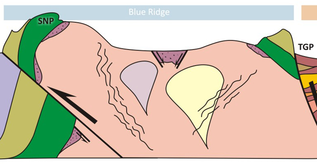
The Chilhowee strata overlie the Catoctin greenstone, a now-metamorphosed series of basalt flows that date to the Neoproterozoic. These overlie immature clastic sediments of the Swift Run Formation, at least in the western Blue Ridge province. In the east, there’s an equivalent unit called the Fauquier Formation. I’ve also included the Mechum River Formation in my sketch – a belt-like package of similar Neoproterozoic clastics in the central Blue Ridge province. I drew it here as a graben, but after I posted this piece this morning, Chuck Bailey wrote to correct me that the analysis he and colleagues conducted on these rocks indicate the faults on the southeast side are reverse, not normal. Beneath all of these sedimentary rocks is the Blue Ridge basement complex: various plutons and their metamorphosed descendents, criss-crossed by anastamosing shear zones and Catoctin feeder dikes.
Half an hour later, I reach Bull Run Mountain, and cross it via Throroughfare Gap (TGP), a water gap cut by Broad Run. Structurally, Bull Run Mountain is a mirror image of the Blue Ridge, at least in the broadest of strokes. It’s the eastern limb of the Blue Ridge Anticlinorium. The mountain is held up by quartz sandstones of the Weverton Formation, one of the Chilhowee units.
On the far (eastern) side of Thoroughfare Gap, my car leaves the Blue Ridge and enters the Culpeper Basin, a failed rift that opened up during the Triassic and Jurassic.
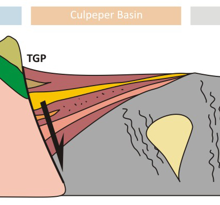
During the Mesozoic, the Culpeper Basin was trying its damnedest to become a proper ocean basin. However, its cousin to the east, the Atlantic Basin, kept opening wider and wider, and eventually split down the middle to initiate seafloor spreading, and the Mid-Atlantic Ridge. The Culpeper Basin stopped subsiding, and filled in with dirt and mafic volcanics. You can find dinosaur footprints in some of its layers. It’s one of many “Newark Supergroup” basins that stretch up and down the east coast. Even today, the lack of induration in these post-orogenic rocks means that they weather out in low relief, and the Culpeper Basin is sometimes called the “Triassic Lowland.”
At Centreville, the car climbs up a short rise and emerges onto the crystalline rocks of the Piedmont “plateau.” This is the crushed-up, mangled, tortured remains of the Iapetus Ocean basin. They are metamorphosed oceanic sediments and volcanic island arc rocks, various terranes that “wrecked” against the edge of the ancestral North American continent.
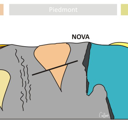
These rocks have lost most of their original stratification, and are folded, foliated, and faulted as well as being recrystallized. Granites and other plutonic rocks intruded them in many places. Ophiolite slices (metamorphosed slabs and slivers of oceanic crustal rocks) may be found in the Piedmont, too. One set lies just beyond the goal of my commute (NOVA) in Annandale, Virginia, exposed in the gully cut by Indian Run, behind the Annandale Library.
If I were to keep traveling east, back to my old digs in DC and across the Fall Zone, I would enter the Coastal Plain province, a relatively subdued landscape with tidewater rivers.
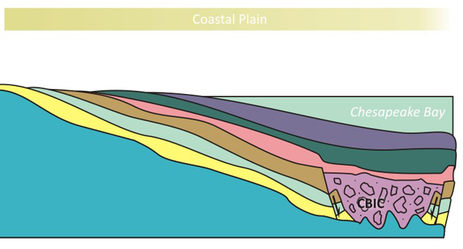
The geology there is dominated by sedimentary strata that dip gently east, under Chesapeake Bay and the Delmarva Peninsula, and out onto the Atlantic continental shelf. There are Cretaceous layers at the base, and lots of Miocene strata in the stack. One feature that mars this otherwise sedate pile of blanket-like layers is the Chesapeake Bay Impact Crater (CBIC), a late Eocene astrobleme that punctured through the older Coastal Plain strata, but is buried beneath younger Coastal Plain strata. A cylinder of impact breccia overlies the sombrero-shaped crater itself, which is excavated into the underlying crystalline rocks. (We would call them “Piedmont” rocks if they were exposed on the surface).
In making this commute, I traverse about 1.1 billion years of geologic history, and two complete Wilson Cycles of supercontinent formation and breakup. There route features passive and active sedimentation, compressional structures associated with Grenvillian and then Appalachian mountain-building, and extensional structures associated with the opening of ocean basins several times over (Iapteus, Atlantic). It’s diverse, and epic, and it excites me to think about it all as I drive along.
Who else has a geologically interesting commute? Can it match this one?


I drive down and then parallel to a terminal moraine on an outwash plain. Your commute is WAY cooler. Congrats on the new house.
This is a totally cool presentation of a commute. My commute takes me from Reston, Virginia through the road cuts along the Dulles Greenway that expose some interesting examples of hornfel past an outcrop of Leesburg Conglomerate located just north of Leesburg, Virginia on Route 15.
Interestly, I suppose, is the fact that as of last year’s election in Loudoun County of an all-Republican Board of Supervisors, my commute NOW takes me through an exciting Right Wing Jackass Jurassic Park filled with terrifying examples of the dangerous Teabaggerannosaurus Rex (also known by its popular name as Supervisor Eugene Delgaudio, whose public advocacy group, Public Advocate of the United State, was recently declared by the Southern Poverty Law Center as a hate group), which is opposed to progress, science and other things, like the expansion of the Silver Line (Metro) into Loudoun County.
http://www.huffingtonpost.com/2012/03/26/eugene-delgaudio-hate-group_n_1381033.html
http://loudounoptout.blogspot.com/2011/10/delgaudio-opposes-taxpayer-funding-of.html
My commute to Loudoun County isn’t as geologically interesting as yours, Callan, but it it is much more dangerous…politically speaking. 🙂
This is spectacular, Callan. We drive into the “city” often to visit our daughter in Falls Church. Lord, I hope I don’t wreck now rubbernecking to see if I can catch a glimpse of some of the features . . . not sure I would know what I was looking at but plan to check it out–responsibly! My commute (when school is in session) is from the west side of the North Fork of the Shenandoah, to Sandy Hook Elementary School on the east side. ‘Bout a mile or so, can’t match yours.
My commute is 0.5 miles through Old Town Manassas. On the way I pass by yards that have carriage stones, stones which served as platforms for 19th Century women in hoop skirt alight from carriages. These stones were cut from the sandstone of the local Culpeper Basin. Pale in comparison to your commute, but interesting to me none-the-less