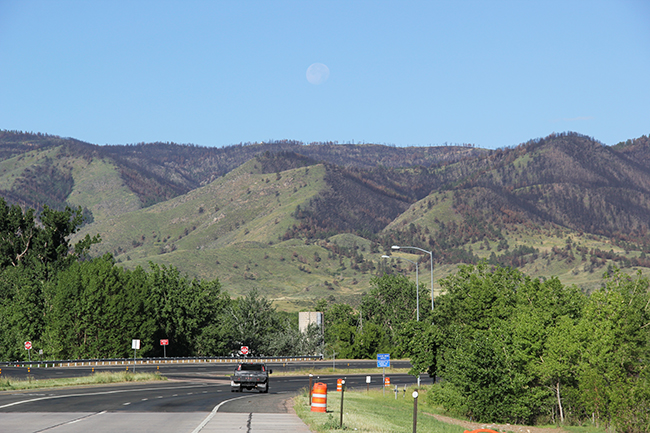
Left side of the hill in the middle is mostly treeless (not due to lack of exposure) and, if I squint, I think the ground is rocky. I was first thinking landslide, too. Other hills are similar, though, so maybe that side was eroded by wind.
Which direction is north and which is south? Something we’ve noticed on our trips out west is that the south-facing slopes often contain far fewer trees than the north-facing slopes, which we presumed was due to hotter and dryer microclimates on the southern exposures. Similarly, in Florida, you’ll often see subdivisions with two entrance signs, one facing south and one facing north, and the south-facing signs are often much more faded than the north-facing signs.
Right on. That’s exactly what I noticed. The difference in vegetation between north- and south-facing slopes on this north-south-trending exposure of the Front Range of the Rockies in Colorado. View is to the west.
Observations:
Vegetation much lower to ground (probably grass) on left side of hills, darker and taller vegetation on the right side of hills (probably trees/shrubs).
Gibbous moon appears above horizon.
Shadows on truck and orange highway barrels point to right and forward.
Hills (generally) have slightly rounded peaks and concave-up profiles as they grade down to lower elevations.
Truck driving on right hand side of road.
Do Not Enter and Wrong Way signs on opposite lane adjacent to the turn-around in the highway median.
Interpretations:
Photograph was taken in North America (based on traffic direction and signage styles).
Camera (and probably driver/photographer) located on highway shoulder, presumably driver saw something and pulled over to take picture.
Camera facing west or west-southwest based on position of moon (mostly illuminated lunar disk requires light source from behind observer), and shadows on barrels (only sliver of shadow visible on right side of barrel – again requiring light source mostly behind observer).
Moon rising in west with sun still above horizon indicates waxing gibbous phase. Given that I saw a waxing crescent last night, this picture was taken about 3 weeks ago at the earliest (if moon cycles every ~4 weeks, you have 1: Waxing Gibbous, 2: Full Moon, 3: Waning Gibbous, 4: Quarter, 5: Waning Crescent, 6: New Moon, 7: Waxing Crescent, 8: Quarter… back to Waxing Gibbous).
Vegetation on left sides of hillslopes shorter due to southern exposure caused by increased solar heating and higher evaporation, less available moisture inhibits tree and moisture-preferring plant growth, so grasses and other dry-habitat vegetation tends to do well on these slopes.
Places where concave-up profile is interrupted suggests landscape changes that have happened recently or on a scale that weathering/erosion have not managed to smooth over yet (mass wasting, tectonic movements, or large-scale climatic changes often do this).
Rugged topography suggests active, or recently active tectonic setting.
Sub-horizontal, light tan “streak” that’s partially obscured by trees may indicate fault scarp, or gravel road.
Other color differences visible between green vegetation patches may be differences in soil/organic material or bedrock. At this scale, bedrock resistance to weatheirng/erosion appears fairly uniform – no distinctly erodible or resistant units.
Trees on the surrounding hills appear to be coniferous, while trees on the side of highway are deciduous. I interpret this as the highway and city are located on the river valley, looking up at the foothills of the rockies.
Anyway, that’s what I’m looking at…
I’ll note that the Moon is actually a waning gibbous as indicated by the visible surface features; there is more maria on the western face of the moon which is visible from full through last quarter. Since it is daytime, the Moon must be in the west and about to set, not to mention it is impossible for the Moon to rise in the west. The location is indeed somewhere in the northern hemisphere because of the angle the Moon makes with the horizon. The time of day is sometime in the morning.
A beautiful hypothesis killed by “ugly” facts, as Huxley would say. I bow to your superior skills of astronavigation and pointing out the features of the waning gibbous – I had said waning gibbous, but I abandoned that because I was convinced the view was to the west…
I will point out for geo-pedagogy’s sake, that my interpretations were what was wrong. I tried to keep my observations just that – items that were in the picture. I specifically put directions not actually part of the photograph (east/west, vs. right/left) as interpretations. So I OBSERVED the moon was in a gibbous phase, but my INTERPRETATION of a waxing gibbous phase was incorrect.
Also a good illustration of how if you become too enamored with one interpretation, it can push you to make additional incorrect interpretations.
I could just erase all the interpretations and start over from the same observations. The OBSERVATION vs. INTERPRETATION game is fun! Even when you lose, if you’re careful with observations, you still win…
He has Barley for Brains! Clearly, he’s got it figgered.
Well done!
The fire scar is something that eludes me still, even after several people have pointed it out, but the location is spot on.
The hills seem to be illuminated from the left. The shadow of the truck is also to the right of the truck. That would seem to place the sun to the left. The moon should also be illuminated from the left and be more of a half-illuminated moon. The moon was probably inserted for effect but they got the science wrong.
No Photoshop trickery here – this photo is as it was when I drove through. Sun was behind and to the left (southeast) of me as I faced west to take this photo.
No one’s yet mentioned that the range of hills in the middle ground appears to have a northward (to the right) structural dip, about 30 or 40 degrees. The ridge on the horizon appears to have a different dip: much more nearly horizontal, perhaps slightly to the south (left). So there seems to be a structural discontinuity, though that could be partly a trick of the perspective. We could be looking at a thrust fault, or even an angular unconformity.

The lower hills, below the skyline and at the level of the street lamps, are a bit “lumpy” — perhaps this is an old landslide deposit? #wildguess
That’s a good observation – not something I noticed, though – and therefore not what I’m driving at… 🙂
Left side of the hill in the middle is mostly treeless (not due to lack of exposure) and, if I squint, I think the ground is rocky. I was first thinking landslide, too. Other hills are similar, though, so maybe that side was eroded by wind.
Good observation. I noticed the same thing – and not just for the hill in the middle…
Which direction is north and which is south? Something we’ve noticed on our trips out west is that the south-facing slopes often contain far fewer trees than the north-facing slopes, which we presumed was due to hotter and dryer microclimates on the southern exposures. Similarly, in Florida, you’ll often see subdivisions with two entrance signs, one facing south and one facing north, and the south-facing signs are often much more faded than the north-facing signs.
Right on. That’s exactly what I noticed. The difference in vegetation between north- and south-facing slopes on this north-south-trending exposure of the Front Range of the Rockies in Colorado. View is to the west.
Observations:
Vegetation much lower to ground (probably grass) on left side of hills, darker and taller vegetation on the right side of hills (probably trees/shrubs).
Gibbous moon appears above horizon.
Shadows on truck and orange highway barrels point to right and forward.
Hills (generally) have slightly rounded peaks and concave-up profiles as they grade down to lower elevations.
Truck driving on right hand side of road.
Do Not Enter and Wrong Way signs on opposite lane adjacent to the turn-around in the highway median.
Interpretations:
Photograph was taken in North America (based on traffic direction and signage styles).
Camera (and probably driver/photographer) located on highway shoulder, presumably driver saw something and pulled over to take picture.
Camera facing west or west-southwest based on position of moon (mostly illuminated lunar disk requires light source from behind observer), and shadows on barrels (only sliver of shadow visible on right side of barrel – again requiring light source mostly behind observer).
Moon rising in west with sun still above horizon indicates waxing gibbous phase. Given that I saw a waxing crescent last night, this picture was taken about 3 weeks ago at the earliest (if moon cycles every ~4 weeks, you have 1: Waxing Gibbous, 2: Full Moon, 3: Waning Gibbous, 4: Quarter, 5: Waning Crescent, 6: New Moon, 7: Waxing Crescent, 8: Quarter… back to Waxing Gibbous).
Vegetation on left sides of hillslopes shorter due to southern exposure caused by increased solar heating and higher evaporation, less available moisture inhibits tree and moisture-preferring plant growth, so grasses and other dry-habitat vegetation tends to do well on these slopes.
Places where concave-up profile is interrupted suggests landscape changes that have happened recently or on a scale that weathering/erosion have not managed to smooth over yet (mass wasting, tectonic movements, or large-scale climatic changes often do this).
Rugged topography suggests active, or recently active tectonic setting.
Sub-horizontal, light tan “streak” that’s partially obscured by trees may indicate fault scarp, or gravel road.
Other color differences visible between green vegetation patches may be differences in soil/organic material or bedrock. At this scale, bedrock resistance to weatheirng/erosion appears fairly uniform – no distinctly erodible or resistant units.
Trees on the surrounding hills appear to be coniferous, while trees on the side of highway are deciduous. I interpret this as the highway and city are located on the river valley, looking up at the foothills of the rockies.
Anyway, that’s what I’m looking at…
Matt,
You are an impressive beast. Well done, indeed.
-C.
I’ll note that the Moon is actually a waning gibbous as indicated by the visible surface features; there is more maria on the western face of the moon which is visible from full through last quarter. Since it is daytime, the Moon must be in the west and about to set, not to mention it is impossible for the Moon to rise in the west. The location is indeed somewhere in the northern hemisphere because of the angle the Moon makes with the horizon. The time of day is sometime in the morning.
All correct! Well done.
A beautiful hypothesis killed by “ugly” facts, as Huxley would say. I bow to your superior skills of astronavigation and pointing out the features of the waning gibbous – I had said waning gibbous, but I abandoned that because I was convinced the view was to the west…
I will point out for geo-pedagogy’s sake, that my interpretations were what was wrong. I tried to keep my observations just that – items that were in the picture. I specifically put directions not actually part of the photograph (east/west, vs. right/left) as interpretations. So I OBSERVED the moon was in a gibbous phase, but my INTERPRETATION of a waxing gibbous phase was incorrect.
Also a good illustration of how if you become too enamored with one interpretation, it can push you to make additional incorrect interpretations.
I could just erase all the interpretations and start over from the same observations. The OBSERVATION vs. INTERPRETATION game is fun! Even when you lose, if you’re careful with observations, you still win…
I see a burned area on US 287 near Cache La Poudre Canyon. Bedrock is PC core of the Front Range uplift. Ted’s Place is just up the road a bit.
Conclusion: Picture was made in Northern Colorado at this approximate location: -105:10:10.41 40:39:04.26
Based on what I see in Google Earth, I’d say Barley Brains knows what he’s talking about. Old fire scar works for me.
He has Barley for Brains! Clearly, he’s got it figgered.
Well done!
The fire scar is something that eludes me still, even after several people have pointed it out, but the location is spot on.
The hills seem to be illuminated from the left. The shadow of the truck is also to the right of the truck. That would seem to place the sun to the left. The moon should also be illuminated from the left and be more of a half-illuminated moon. The moon was probably inserted for effect but they got the science wrong.
No Photoshop trickery here – this photo is as it was when I drove through. Sun was behind and to the left (southeast) of me as I faced west to take this photo.
No one’s yet mentioned that the range of hills in the middle ground appears to have a northward (to the right) structural dip, about 30 or 40 degrees. The ridge on the horizon appears to have a different dip: much more nearly horizontal, perhaps slightly to the south (left). So there seems to be a structural discontinuity, though that could be partly a trick of the perspective. We could be looking at a thrust fault, or even an angular unconformity.
Hmm. Not sure I can make that out… But thanks for chiming in!
…looks like pine beetle damage to me…
What specifically?