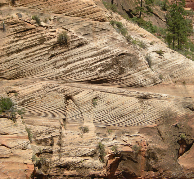
I got a comment the other day on an old post on this blog, one showing beautiful cross-bedding at Zion National Park. These are dune sands – windblown at the time of deposition, and cemented in place for millions of years thereafter. These are petrified sand dunes!
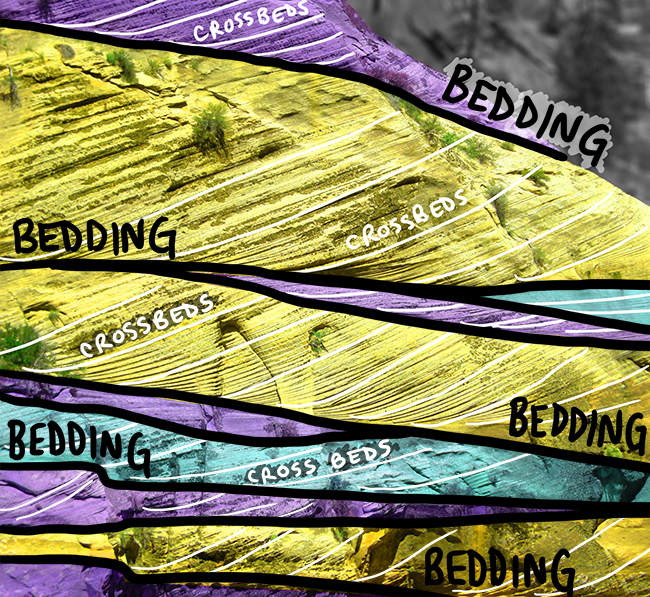
The commenter asked about annotation, so I took ten minutes and modified the picture to highlight the key features as I saw them. Here’s the original…
And here’s the annotation:
I kind of like how that came out. It reminds me of stained glass!
I didn’t draw arrows on showing which way the wind must have been blowing in order to deposit this sand with cross-bedding in the orientation seen (dipping to the left).
In my mind there are multiple stages to the photo annotation process, and at this point I’ve tried to stay strictly observational, without dipping into interpretation. Wind current direction would be an example of information extracted from the raw, basic observations. It’s a higher-order sort of data.
So, students: Can you figure out which way it must have been blowing?


I don’t know the directional data of this photo but … the dip is to the left and winds are named by the direction they came, so it’s a lefterly wind.
Hmm. So you’re saying the layers of sediment represented by the cross-beds accumulated on the side of the dunes that was facing into the blowing wind?
Is that where the sand piled up relative to the wind-blocking bush in this picture? http://academic.brooklyn.cuny.edu/geology/leveson/core/linksa/ROCK%20CYCLE/sinai_5.gif
Think again about the energy of the air currents on the stoss (up-wind) side of the dune vs. the lee (down-wind) side…
Argh. My notes were wrong in my fieldbook and they stood uncorrected upon return, so I’ve been walking around thinking I know something. Alas. So now it goes back to what it seems to be via intuition, so that’s good!
Thank you for the post and the thought questions – I really appreciate it!
Any insight as to the overall regional geology first? Tilted / inverted series? (I doubt it but hey, for the sake of completeness…)
Here’s a primer: http://www.nps.gov/zion/naturescience/geologicformations.htm
It’s the Colorado Plateau, so no inversion: but the cross-beds themselves can tell you that: See how they are tangential with the main bed at the bottom, but make an abrupt acute angle at the top? That tells you these beds are right-side-up. It’s a prime example of a “geopetal” structure – a signature feature that looks different when flipped upside down.
Sure thing, was really to be complete (weird stuff happens!).
And I’d say “wind comes from the right of the pic”. Some major surfaces erosional.
My interpretation of this outcrop is that the winds were blowing from the left towards the right depositing sand along the lower slopes or windward side of the dune.
Answer time: right to left!
The sand accumulates in the slightly-lower energy environment of the lee side of the dune.
The cross-beds dip in the same direction that the wind blows.
Thats what I thought, all I see are the cross beds moving to the left over time, indicating that the dunes are moving left, in the direction of the wind.
What’s the scale on these things? They look pretty big…
1-5 m tall, I think. Those trees are typical Colorado Plateau trees – i.e., not stunted or anything.