
The Wallbridge Unconformity is a surface of stratigraphic hiatus or erosion between the depositional influence of the Tippecanoe and Kaskaskia epeiric seas. After Alan Pitts and I located ourselves in the Oriskany Sandstone (terminal Tippecanoe stratum), we looked stratigraphically above the quartz sandstone for the overlying unit, which should be the Needmore Formation shale (beginning of the Kaskaskia sequence). Indeed, the quartz sandstone was overlain by a black shale at the site:
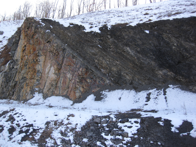
This road cut is on the south side of the highway, facing north. Hence, it was in deep shade when we visited in late afternoon. Uncharacteristically, I see I failed to include a sense of scale in that photo, but the peaklike sandstone outcrop at left is probably about 7 meters tall.
A better exposure can be seen on the north side of the road, where it’s not only sunny, but the contact is more discernible.
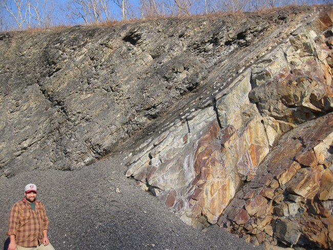
I remembered to include a sense of scale for this shot. Thanks, Alan!
Here’s what strikes me about this exposure: the contact between quartz arenite below and black shale above does not appear to be abrupt or erosional, like I would expect a disconformity to appear. Instead, there are gradually thinner and thinner sandstone beds, and thicker and thicker shale beds. Let’s zoom in:
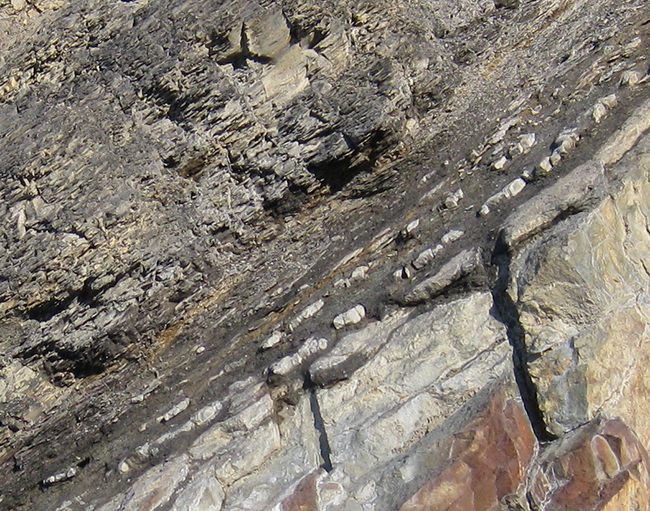
Fundamentally, this looks transitional (conformable). It doesn’t look like an unconformity. But it’s supposed to be one. So what gives?
Interesting. Any chert in there?
Evidently, this section is complicated: http://pubs.usgs.gov/of/2012/1194/pdf/ofr2012-1194.pdf
Also, more in this Geol. Soc. pub. edited by my former undergrad advisor: http://books.google.com/books?id=3hLRklY9pYEC&lpg=PA45&ots=89STKG_KLC&dq=oriskany%20sandstone%20unconformity%20needmore%20devonian%20virginia&pg=PA45#v=onepage&q=oriskany%20sandstone%20unconformity%20needmore%20devonian%20virginia&f=false
I don’t recall any chert (though there was some ~500 feet to the right of the second photo (downsection, in the Helderberg Group), but I wasn’t looking for it, either. Why?
Thanks for the links. Looking forward to reading them.
Callan, I was wondering if there might be some thin Huntersville Chert in there, between the two (based on what I read). Also, I wonder if there might be a shale on shale unconformity, that looks conformable initially. Regardless, it is a neat exposure.
Shale on shale occurred to me to, after reading through something the other day in one of the two papers/books you linked to. Could be…
I’m just spit-balling on this (my sed/strat was never my strongest course) but from the quick bit of research I did on these units I think it comes down to age separating them. Also, and again just spit-balling, if these units were a true representation of a transgression (ideally creating no unconformity) you’d see some interbedding between the SS and the SH. The fact(ish) that you see sandstone, then immediately shale says to me that something else was probably overlying that sandstone and was wiped out. This missing layer would be your unconformity since even though stratigraphically the shale makes sense, it isn’t a true representation of the transitioning depositional environment. I’m just an undergrad tho so thats just my 2 cents.
Thanks for chiming in, Eric! We need more “just an undergrads” as part of the discussion here!
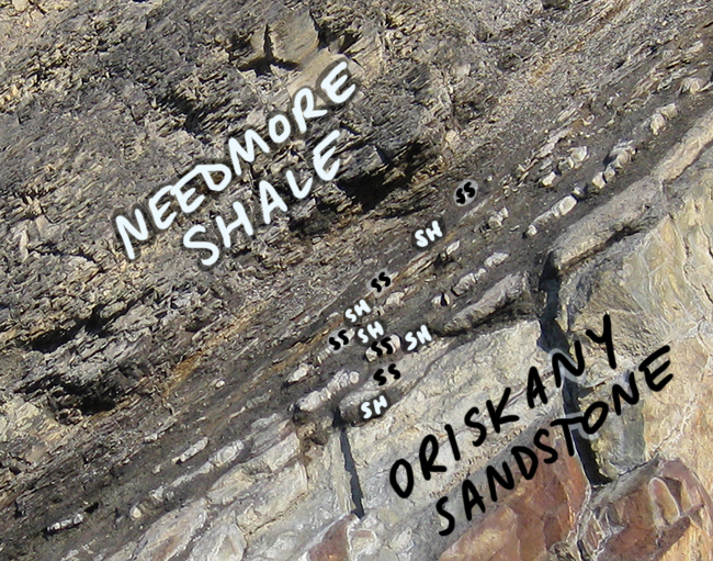
Take another look at the last photo, with the annotations – it’s not a sudden transition from sandstone to shale. The point of my post was that the type of sediment that was deposited oscillated from one type to the other, back and forth, back and forth, before settling into 0% sand & 100% mud.
Could it be that the shale “slipped” over the sandstone during the orogeny and that is why there is less transition? I know that these two formations are normally found together but there does appear to be a rapid transition. Perhaps a combination of transgression and regional subsidence accelerated the transition?
That’s a great thought. I wish I’d had a similar notion while we were out in the field – I would have checked for slicks.
Thats kind of what I was leaning towards as well, but I dont see any minor-structures (S/Z folds) associated with the fold/displacement if the unit initially was displaced as 1. No doubt what we see here represents a uniform displacement but I see a secondary one in the homogeneous layer of the SS unit. On the sandstone unit I see fractures that don’t propogate through to the shale unit which to me also suggest another reason these two units aren’t closely related….if they were I’d assume more minor structures associated with layer-parallel stress. I also can’t tell from the picture but the SH units you have interbedded with the SS appear to be colluvium accumulated on the SS ledges. Unless there was a huge move of sediment I don’t see such thin units of SS mixed with SH happening unless this shale represents unit close to a slope/shelf. I hope you don’t mind but I borrowed your images and added in the detail I’m describing. https://imgur.com/a/k7Up6
It may be that your section was low enough in the basin that it’s barely conformable here but unconformable elsewhere. Looking at that strat section you linked to last post (Fichter), it seems likely that the Oriskany is a shoreface sand (clean quartzarenite, marine fossils, sitting on a shallow water carbonate unit). Perhaps your section was lower shoreface, far enough offshore that the transgression that flooded and scoured more distal locations (upper shoreface and beyond) didn’t cut deep enough to scour here, but left a record of continuous deposition, albeit fairly abrupt, with only a metre or so of “passage beds” (interbedded sand and mud).