
Old Rag Mountain is a distinctive mountain in the eastern Blue Ridge of Virginia, contained in a little lobe of Shenandoah National Park. It’s a great hike on several levels: (1) it’s got no trees on the summit, so you can actually get a decent view from on top, (2) it’s got a great section of full-body rock scrambling on the Ridge Trail, and (3) it’s long (9.2 miles round trip), which is why I brought a group of four of my Rockies students there last Friday for a training hike. Today and tomorrow, I’d like to show you some of the geology we saw there. Here’s one of the most striking geological features to be seen at Old Rag:
The sharp-eyed among you will note that most of the rock in the picture is light-colored and coarse-grained – on both the left and right sides of the photograph. This is the Old Rag Granite, a Mesoproterozoic (~1.04 Ga) granite that intruded in the final phases of the Grenvillian Orogeny, during the assembly of the ancient supercontinent Rodinia.
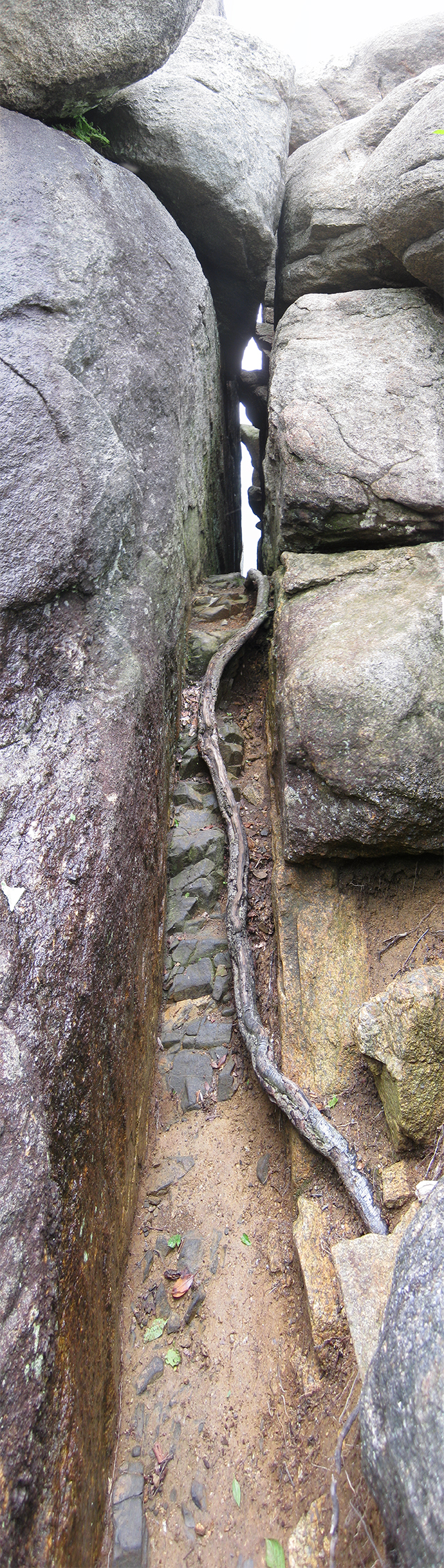
Running through the middle of the photo, however, is something different: a rock that is dark in color, and fine-grained. This vertical seam is a feeder dike of the Catoctin Formation, a Neoproterozoic (~565 Ma) basaltic dike. Flowing through this ancient fracture was basaltic magma that fed surface eruptions of lava that flooded the landscape. Tectonically, this was during the breakup of Rodinia, and the opening of the Iapetus Ocean. The dike was metamorphosed to low-grade greenstone facies much later, during the Alleghanian Orogeny (~300 Ma), during the assembly of the more recent supercontinent Pangaea.
The mafic (iron and magnesium rich) minerals that make up the basalt are less chemically stable at Earth’s surface than the felsic minerals (potassium, sodium, and silica rich) that make up the granite. Consequently, they fall apart (weather) more quickly, and the dike is soon etched into an empty slot in the landscape. Many of these differentially-eroded Catoctin feeder dikes can be seen on the Old Rag hike, mainly on the Ridge Trail. The trail itself actually goes through three of them, which is a very cool perspective – to be walking within the actual slot that once hosted pulsing, gurgling flows of 1100° C magma, bled out during the death throes of Rodinia.
In the last line you mean 1100° C, not F. 1100° F is only ~593° C, far below the solidus of a basalt (or even a granite).
Ooooops. Thanks Ron!
Speaking of weathering features, my eye was drawn to that big(?) block of granite at the top of the photo that’s moved to the right to overhang the gap left by the dike. Frost jacking?
I noticed that too, and a similar orientation to the other granite blocks further on down the line. Not sure…
Hi Callan,
Is there any chance that Old Rag Mountain was covered by alpine glaciers during the Pleistocene? I know the ice sheets advanced no further south than Pennsylvania, but were conditions in Virginia’s Blue Ridge amenable to the localized formation of alpine glaciers? Thanks!
This is a perennial question in Virginia (along with the presence of mountain lions in the modern day is the question of whether there were any true glacial effects here!). I see it as unlikely due to low latitude, low elevation, and modest area of the peak. There are plenty of well-documented peri-glacial features such as “felsenmeer” boulder fields, but no one has yet laid out a convincing case for either erosional or depositional landforms that resulted from true glaciation.