
I was out on Corridor H last week, looking at rocks with my Honors student, and on the way back from the field work, I noticed this:
 Click to enlarge

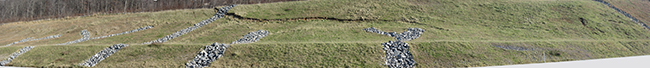
That’s a fresh slump scarp running across a slope that is gradually sliding downhill. (The left half of the image is moving down relative to the right.) To judge from the rip-rap-filled culverts, this slope must have a previously-documented history of instability, which the highway department attempted to control, but didn’t succeed.
I’ll keep my eye on it in the months to come and let you know how it develops.
A drive by on Rt 48 (a.k.a. Corridor H) or a vicarious Google-Earth based trip reveals the photo includes just the southern end of the slump. Flagged by the Y-shaped limestone-lined drainage pattern, the slump scarp on the photo is apparent in 19 November 2013 Google Earth imagery, about 900 m SSW of Greenland, WV. Scrutiny of this 2013 image, with an eye height of 1200-1500 m (3500-5000 ft), suggests the slump scarp extends into the forest above the clearing, I will try to confirm with field work next month, but it appears total scarp length exceeds 200 m.