Correctly tell me what’s going on here, and you get A Big Prize!
0 thoughts on “Contest: interpret this outcrop”
Hi Callan,
I love these quizzes, so I couldn’t resist to participate.
Here’s my interpretation of the outcrop:
The brownish unit, where the lens cap is placed, looks like glacial sediment: unconsolidated, variable size and somewhat rounded quartzite clasts. On top, there is a lava flow, with a dark, fine-grained and vacuolar lower part, and a slightly lighter upper part, where some flow structures can be distinguished. The former structure probably originated during the fast cooling of the lava in contact with the cold surface.
The light cobbles are also made up by quartzite, but their roundness indicate that they were formed in a river (the former glacier disappeared).
Additional guesses.
Age: The quartzite is Paleozoic, the rest of the processes (glacier, vulcanism and river) are Cenozoic.
Location: I’m gonna go with Alaska or roughly NW USA.
Hello Callan,
The bottom portion seems to be a poorly sorted, clast supported conglomerate with possibly 5% silt. It’s a little hard to tell, but there is possible imbrication of the clasts in position coming out of the screen, there is no grading. It was probably a stream deposited conglomerate from an alluvial fan. There is a sharp boundary between the beds, so the top layer must have come in very suddenly. I wish I could be there because its a bit hard to tell if this was a flow coming from a nearby volcano or if its is just a thick layer of mud that would indicate a change in energy and depth. Giving that the material in the bed below is very similar to the cobbles around the outcrop I will go with lava flow. The flow itself seems to be similar to pahoehoe flows. The deposition setting had to be in very close proximity to the volcano itself or we would be looking at ash deposits. The surrounding material came in after the lava flow and is poorly sorted. It indicates that it was deposited in a high energy environment. It also seems to be sub rounded to rounded. The clasts seem to be well sorted quartz sandstones and granite that was being transported by a river towards a beach setting. Because of the poor sorting this setting is probably close to the head of the the stream. The stream has now abandoned the area and has changed direction or dried out.
Best,
-Isabel Y.
Tough. All the loose stuff looks recent, edge-rounded and flat fluvially influenced gravel compared to the more angular and poorly-sorted clasts that are in situ underneath the lens cap (and below the dark-brown competent unit). But they might be clasts from the same provenance, simply reworked? That gravel unit/conglomerate below the dark-brown-reddish competent unit might represent the upper part of an alluvial fan or even a scree slope.
The dark-brown-reddish competent unit sure does look like a thin lava flow. Darker, more mafic at the base, and lighter more scoriaceous (?) at the top; it either represents two different flows (or pulses) or (more likely) differentiation during cooling.
Then there are all those nice flattish and edge-rounded fluvial poorly sorted gravels lying around. They probably represent terrace deposits of some river above the lava level, which are now eroding all over the place as whatever river deposited them (or descendant of that river) has now cut down through the terrace and the other two units.
The interpretation necessarily lends to dating the units as late Cenozoic or even more recent. BTW, most all the cobbles, gravels, etc. appear to be carbonates. Reminds me of some of the limestones or dolomites in the Mississippian or lower in the Paleozoic of the western US.
If I had to guess, I’d say this might be in the area of the Yellowstone or westward into Idaho (SW Montana?). But that’s a wild guess. Could be in/nearby the Rio Grande Rift.
I’m slightly guessing based on where you went this Summer…..
The brown layer looks like it could be peat. There is a layer of cobbles over everything, suggesting we are near a wild modern seashore.
The layer underneath is very poorly sorted with a wide range of angular clasts.
Peat with unusual layers of high-energy deposits in it reminds me of the tsunami deposits found in Shetland.
If I’m right, then an innocent peat bog near but above the Scottish coast line is suddenly inundated by a layer of sediment deposited by a tsunami event formed by a massive undersea slope failure in Norway.
Things go back to normal and more peat is laid down. Later glacial uplift exposes these layers near the modern day seashore where an intrepid US geologist makes a pilgrimage on his remarkable summer of Scottish geology.
Well done, Simon and Bill! The answer has been posted. What do you want for your prize? Simon, perhaps you’d appreciate a Chesapecten jeffersonius, state fossil of Virginia? Bill – I’m sure you’re already well stocked on those. Maybe a guest blog post?
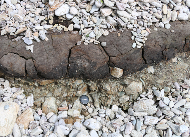 Lens cap for scale.
Hi Callan,
I love these quizzes, so I couldn’t resist to participate.
Here’s my interpretation of the outcrop:
The brownish unit, where the lens cap is placed, looks like glacial sediment: unconsolidated, variable size and somewhat rounded quartzite clasts. On top, there is a lava flow, with a dark, fine-grained and vacuolar lower part, and a slightly lighter upper part, where some flow structures can be distinguished. The former structure probably originated during the fast cooling of the lava in contact with the cold surface.
The light cobbles are also made up by quartzite, but their roundness indicate that they were formed in a river (the former glacier disappeared).
Additional guesses.
Age: The quartzite is Paleozoic, the rest of the processes (glacier, vulcanism and river) are Cenozoic.
Location: I’m gonna go with Alaska or roughly NW USA.
Nice idea, by the way.
Best regards
Pedro
Hello Callan,
The bottom portion seems to be a poorly sorted, clast supported conglomerate with possibly 5% silt. It’s a little hard to tell, but there is possible imbrication of the clasts in position coming out of the screen, there is no grading. It was probably a stream deposited conglomerate from an alluvial fan. There is a sharp boundary between the beds, so the top layer must have come in very suddenly. I wish I could be there because its a bit hard to tell if this was a flow coming from a nearby volcano or if its is just a thick layer of mud that would indicate a change in energy and depth. Giving that the material in the bed below is very similar to the cobbles around the outcrop I will go with lava flow. The flow itself seems to be similar to pahoehoe flows. The deposition setting had to be in very close proximity to the volcano itself or we would be looking at ash deposits. The surrounding material came in after the lava flow and is poorly sorted. It indicates that it was deposited in a high energy environment. It also seems to be sub rounded to rounded. The clasts seem to be well sorted quartz sandstones and granite that was being transported by a river towards a beach setting. Because of the poor sorting this setting is probably close to the head of the the stream. The stream has now abandoned the area and has changed direction or dried out.
Best,
-Isabel Y.
Tough. All the loose stuff looks recent, edge-rounded and flat fluvially influenced gravel compared to the more angular and poorly-sorted clasts that are in situ underneath the lens cap (and below the dark-brown competent unit). But they might be clasts from the same provenance, simply reworked? That gravel unit/conglomerate below the dark-brown-reddish competent unit might represent the upper part of an alluvial fan or even a scree slope.
The dark-brown-reddish competent unit sure does look like a thin lava flow. Darker, more mafic at the base, and lighter more scoriaceous (?) at the top; it either represents two different flows (or pulses) or (more likely) differentiation during cooling.
Then there are all those nice flattish and edge-rounded fluvial poorly sorted gravels lying around. They probably represent terrace deposits of some river above the lava level, which are now eroding all over the place as whatever river deposited them (or descendant of that river) has now cut down through the terrace and the other two units.
The interpretation necessarily lends to dating the units as late Cenozoic or even more recent. BTW, most all the cobbles, gravels, etc. appear to be carbonates. Reminds me of some of the limestones or dolomites in the Mississippian or lower in the Paleozoic of the western US.
If I had to guess, I’d say this might be in the area of the Yellowstone or westward into Idaho (SW Montana?). But that’s a wild guess. Could be in/nearby the Rio Grande Rift.
I’m slightly guessing based on where you went this Summer…..
The brown layer looks like it could be peat. There is a layer of cobbles over everything, suggesting we are near a wild modern seashore.
The layer underneath is very poorly sorted with a wide range of angular clasts.
Peat with unusual layers of high-energy deposits in it reminds me of the tsunami deposits found in Shetland.
If I’m right, then an innocent peat bog near but above the Scottish coast line is suddenly inundated by a layer of sediment deposited by a tsunami event formed by a massive undersea slope failure in Norway.
Things go back to normal and more peat is laid down. Later glacial uplift exposes these layers near the modern day seashore where an intrepid US geologist makes a pilgrimage on his remarkable summer of Scottish geology.
I agree–peat overlying gray, angular gravel–maybe oozed out a bit?–with veneer of modern, white, rounded gravel.
Well done, Simon and Bill! The answer has been posted. What do you want for your prize? Simon, perhaps you’d appreciate a Chesapecten jeffersonius, state fossil of Virginia? Bill – I’m sure you’re already well stocked on those. Maybe a guest blog post?