

Following yesterday’s discourse on the logistics of virtual samples, I wanted to showcase some new collections of images, focused on giving students practice with relative dating.
Relative dating collection I (36 outcrops and samples)
Relative dating collection II (24 outcrops and samples)
These are super-high-resolution images (GigaPans and GIGAmacros). As with all my GigaPan stuff, you can zoom in to great detail in each of these images. The advantage of having them all gathered on a single web page is that it’s a single URL for instructors to deploy as an access point for their students. In this case, the images are united in a theme of having some sort of relative dating story to be told. Though the details vary by image, the concepts covered include superposition, lateral continuity, original horizontality, inclusions, overprinting (by tectonic fabrics) and cross-cutting relationships. There are igneous intrusions, folded sedimentary rocks, and several kinds of unconformities. The images featured are mostly mine, but also include a substantial contribution from my colleague (and former student) Robin Rohrback, and a handful from other student researchers and 3 more from my colleague Ron Schott.
I used five of the images on the first page in Historical Geology class the other day, one at a time (I told students to bring their computer or smartphone or tablet in advance). After they worked on exploring and thinking about an image individually for a few minutes, I then reviewed it as a class discussion. Then I assigned another: “Try number 4 next!” and so on. In the discussion portion of the lesson, I was able to offer prompts, such as “if this sill is isotopically dated as being 300 million years old, then how old are the sedimentary layers it intrudes?” Then I gave them another set of images to do for homework.
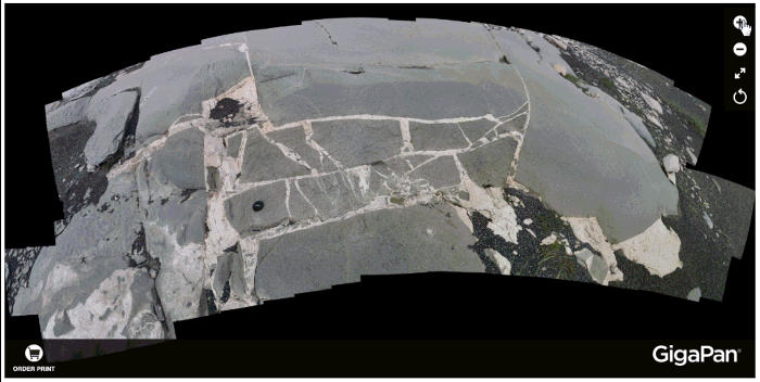
It’s a nice switch-up for applying the principles of relative dating to real-world rocks. I also think it’s valuable because it weaves in rock identification skills with the relative dating concepts. I share this compilation with you teachers in the hopes that it may be useful as the basis of an in-class exercise or a homework assignment.
If you want more detail on the sequence of events/rocks in any of these images, I’d be happy to share their story – but you can doubtless work out the key things in each one on your own. Some are more straightforward than others.
It strikes me that people might feel overwhelmed by the numbers of images per page, and there’s an argument to be made for smaller groups of samples. So here are the same images, but now organized into 5 smaller pages of a dozen images apiece:
Relative dating sub-collection A (12 outcrops and samples)
Relative dating sub-collection B (12 outcrops and samples)
Relative dating sub-collection C (12 outcrops and samples)
Relative dating sub-collection D (12 outcrops and samples)
Relative dating sub-collection E (12 outcrops and samples)
Here’s how I envision you using these. Deploy one set for a pre-lesson homework assignment to warm your students up, then another set/page for an in-class exercise, then a third for a post-lesson homework assignment, all offering opportunities for the students to get feedback from their instructor, both affirmational and corrective. Then there’s a couple sets left in reserve: one for extra practice for students who need it / want it, and another for a final summative assessment.
I welcome your feedback and thoughts.
Callan,
You mentioned in yesterday’s post that it has been a very painful process to port your 3D file over. We are currently engaging a consultant to help us streamline some of our painful processes that require repetitive actions to compile data – mostly hydrological at the moment but I have ideas for others. The consultant is just starting out and may consider some pro-bono work to be able to display his services to perspective clients. Let me know if you are interested and I can have him contact you to see if he can be of service.
And thanks for sharing! As an illiterate geologist (read: geotechnical engineer) I am learning a lot from your posts 🙂
Thanks Charlie!
The 3D stuff is actually the least painful; it’s the 2D but high res GigaPan images that have been a source of so much frustration.
But sure – I would be happy to chat w/ your consultant and discuss useful tasks.