
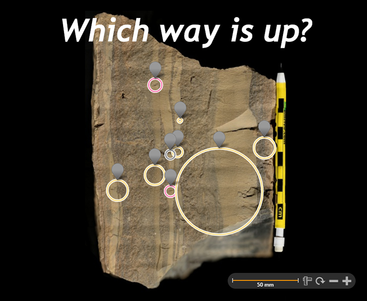
Yesterday I finished a new GIGAmacro image, a view of a chunk of Tonoloway Formation showing what I thought were exquisite graded beds in these Silurian shallow-water carbonates. Closer examination revealed several other primary sedimentary structures with geopetal value: desiccation cracks (“mud cracks”) in cross-section, with their V’s opening upward, and a small instance of scouring and filling, where the pre-existing mud deposit was eroded by energetic sand transport, and sand filled the resulting hollow. Three for the price of one, in terms of determining younging direction. There were also some ambiguous mud cracks, and at least one example where the V pointed the wrong way. But the preponderance of the evidence was pretty clear to me, and I thought it was a good teaching example. I deliberately imaged it with bedding “vertical” in the frame of the image. Here it is:
I posted a link to the GIGAmacro on Twitter and asked:
Students: Which way is stratigraphic “up?” There are three primary sedimentary structures here to clue you in to younging direction: https://t.co/iyVo31fHB6
— Callan Bentley (@callanbentley) May 6, 2018
As you can see, about a third of respondents chose “left” and two thirds picked “right.” In this case, right is correct. (“It’s right!”) But since 1 out of every 3 respondents picked incorrectly, it appears there is a lesson to be taught here. To make the case for why stratigraphic “up” is to the right, consider this annotated copy of the image:
Click on the different annotations and see if you agree. I’ve marked the “right is up” ones with yellow circles, the ambiguous ones in pink, and the “right is wrong” one in gray.
Thanks for playing! More of this sort of thing in the future, utilizing the capabilities of the powerful GIGAmacro imagery viewing platform.
As this it is quite impossible to get the sequence of sedimentation wrong in this very clear example of ‘way up’; then presumably at least 1/3 guessed incorrectly which implies some thing like 1/3 guessing correctly! So only 1/2 were capable of deducing this most basic of scientific principles for them selves.
Oh dear mind you I have collected many examples of textbooks written for geology teachers which state that the Earth’s Mantle is liquid and many more examples where ‘earth from space is printed as a mirror image!!! – What is this world coming to.
Ok, I don’t get it. It just looks like an ordinary photo of a piece of the Tonoloway Fm. (what’s giga about it?) that you can zoom in on. And not a particularly good example, at least for beginning students. So, what, exactly, is the big deal?
Hi Bob,
It’s a gigapixel image: 3.84 gigapixels, to be precise. It shows beautiful graded beds which I think are appropriate not only for beginning students, but also for the old-timers who appreciate the finer things in life. You can zoom in on features like smaller-scale graded beds, or measure grain size or rotate it back into what you think was its original horizontal orientation, or discover scours and tapering mudcracks. There’s lots to explore. Try clicking on one of the circles in the second image (the annotated one) and see what you can see if you zoom in. If you’re not impressed, that’s your call, but I think it’s a pretty great teaching specimen. 🙂