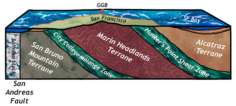
This week marks the launch of a project I’ve been working on for a year and a half: “Streetcar 2 Subduction,” a revision of Clyde Wahrhaftig’s classic field guide to the geology of the San Francisco Bay area. Working with Jamie Kirkpatrick of McGill University (the project’s leader) as well as Christie Rowe (also from McGill), Kim Blisniuk of San Jose State University, and John Wakabayashi of Cal State Fresno, we used brand-new content creation tools in the web-browser-based version of Google Earth to make a series of digital field guides.
These field guides are combinations of Google Earth, Google Maps Streetview, photographs, diagrams, and video, with links out to additional resources in the textual description of each site. Google allowed our team early access to the tools, which allowed us to build the trips over the past six months as “trusted testers” and launch the revised guide only a week and a half after Google released the content creation tools to the public. We greatly appreciate their trust, and are quite pleased with a blog post they wrote and published yesterday about the project.
You can access the trips on a laptop via the Chrome browser, or you can use them in the field with your smartphone and the Google Earth app.

AGU supported the revision effort with Centennial funding, and also tasked AGU staff with assisting: Brandon Bobosink was the project manager, Jenny Lund did editing, and Derek Sollosi edited our videos. Each made valuable contributions to the project, and the scientists on the project are very grateful for their expertise. Our goal was to separate wheat from chaff, and to update the science, and most importantly to make the rich geological history of the Bay area more accessible to more people.
The launch coincides with a bunch of anniversaries:
- the 100th birthday of AGU
- the 100th birthday of Clyde Wahrhaftig
- the 35th anniversary of the publication of the original guide
We’ve released 7 trips at this point, with another 3 due out next month. Each trip has between 2 and 30 sites where geological insights can be gained: vistas and outcrops, rocks and structures, landforms and history. The trips are all free, and will continue to be so in perpetuity. AGU has also made a PDF of the original guide available to commemorate the revision.
Here is a link to the landing page for the project, with links (under “Streetcar trips”) to the various digital field guides: https://www.agu.org/learn-and-develop/learn/streetcar2subduction/streetcar2subduction. Because that is a very long URL, we also made this short one for easier sharing: https://tinyurl.com/agusts
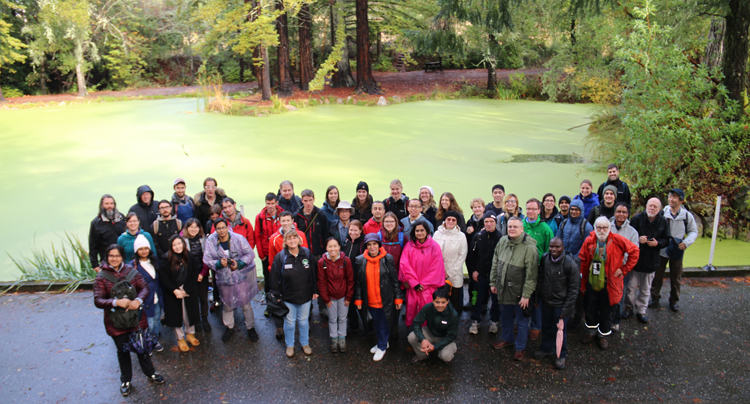
To promote the launch of the guide, our team led two field trips on Sunday, one north to look at Franciscan complex rocks related to Mesozoic subduction, and another south to look at deformation along the traces of the San Andreas Fault and the Hayward Fault. Here’s the active tectonics trip posing in front of a sag pond developed along a right step in the right-lateral San Andreas Fault:

More than a hundred people participated in the two trips! We feel really good about that.
If you’re at the AGU Fall Meeting today, there are several Streetcar related activities:
- We have convened a companion session on the geology and tectonics of the Bay area, which starts at 10:20 with a talk by John Wakabayashi (not to be missed!).
- We have a poster session too, this afternoon.
- At 1:30pm at the Google booth in the exhibit hall, Jamie Kirkpatrick, the project lead, will be giving a 15 minute talk on the new
 guide and how we built it.
 - At 2:30pm, I’m taking an group of folks on an informal, unofficial field trip to Corona Heights park to see the fault and the view over the city. Send me an email if you want to join us.
Eos ran an article about the project a few days ago: https://eos.org/agu-news/a-streetcar-for-the-digital-age and that’s a good place to learn some of the basics if you’re curious. They also published a rembrance of Clyde Wahrhaftig, the original Streetcar author here: https://eos.org/articles/the-layered-legacy-of-clyde-wahrhaftig
A piece on the project aired on the local ABC news affiliate last night: https://abc7news.com/science/scientists-create-google-earth-geology-tour-of-the-bay-area/5742781/, in which Christie does a great job explaining our motivations, and the reporter, Liz Kreutz, does a great job walking people through how to use it.
KQED science also featured the project in a brief piece here: https://www.kqed.org/science/1951470/take-a-google-earth-tour-of-the-bay-areas-most-epic-rock-formations
More press soon, I hope… 🙂

There is an even more impressive chert strike-slip fault on 14th Avenue just south of Ortega Street. It’s very hard, smooth, and flat. It’s riding on top of a softer rock layer. This was also a quarry site as evidenced by dynamite holes and abandoned slabs of rock.
Very cool. Here’s a Google Maps Streetview for anyone who wants to check it out.