
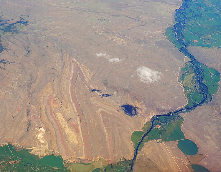
My friend and colleague Mike Plautz sent me this photo today, from an airplane above the region east of Dillon, Montana.

I dialed up the contrast and saturation of the photo to make it “pop” a bit more, and I’m pleased with the result. Many, many geology students will recognize this site, a patch of BLM land called Sandy Hollow, adjacent to Block Mountain (just northeast of the cloud shadows). It’s a favorite mapping site for field camps. As such, I won’t say any more here about its structure; but I did want to share this wondrous site with Mountain Beltway readers. It’s too good to pass by.
Wonderful spot and photo. Being mapped virtually, I’m sure, by field courses that are unable to be in the field.
A very nice photo with obvious geology, and undoubtedly a great mapping project for field courses working in Montana. The structure and rock relationships toward the upper right are reminiscent of a popular field course mapping area in New Mexico that I need to share photos of when I get a bit of time. As always, these posts are a great way to end the work week!
This is a remarkable area, not just for the folding, but also for the faults that are a key interrelated part of the structural geology of the area. The IU Field course (G429) used to map this area as part of an exercise comparing structure and stratigraphy of the Montana transverse zone to the northeast with that of the thrust belt.
Complex history there. Just ask the local Montana State University structural geologist.