
I’ve developed a little cartoon diagram to show four stages of river landscape evolution. I use this image in Physical Geology when discussing how running water erodes the land. Check it out:
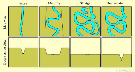
There are two rows, and four columns. The columns are the four stages of river landscape evolution: youth, maturity, old age, and rejuvenation. The rows offer different perspectives on the landscape: the upper row is a map view, and the lower row is a cross-sectional view.
The first two columns are shown here in more detail:
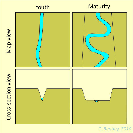
When they are young, rivers ideally start out relatively straight in map view, entrenched in V-shaped valleys. You’ll also find plenty of waterfalls and rapids at this “Youth” stage. As time goes by, the river erodes downward to base level, and loses the gravitational impetus to incise any deeper. The river now begins to meander side to side, and as it does so, enlarges the size of its valley by lateral erosion at cut banks. It is “Mature.” As time goes by, the valley walls get further and further apart. …Then what?

If enough time goes by, the river can enlarge the size of its valley so much that you can’t really tell it’s a valley any more. At this stage, meandering can get pronounced enough to fold back on itself and create oxbow lakes (visible in the map view of the “Old Age” stage). The story could conceivably end here. However, if base level were to drop anew, the river will begin to incise again, producing a valley profile (cross-section) that looks pretty much identical to the “Youth” stage. It has been made young again, or “Rejuvenated.” In map view, however, you can see from the meandering shape of the re-incised valley that the river must once have been at the “Old Age” stage. There are no more oxbow lakes in the “Rejuvenated” stage, as the river’s energy is going into downcutting rather than lateral meandering.
My experience is that this nice neat sequence works as a conceptual model for Physical Geology students. Nature, of course, is more complicated, but this serves me well as a foundational framework. What do you think? Is this scheme appropriate for an introductory audience, or is it too simple?
I hope a fluvial geomorphologist will weigh in on this. (I know Anne’s traveling. Maybe Kyle?) One geomorph colleague of mine told me not to teach rivers in this way – that the idea that rivers go through a consistent evolution was dated and that it’s better to think about driving forces (climate, tectonically forced topographic changes).
But I’m not a geomorphologist.
I second Kim: I’m don’t know enough to weigh in on the pedagogical implications of this approach. It is the way I learned fluvial geomorphology, and it has served me well, but my profs always emphasized that it was a metaphorical description, not reflective of the real world. For example, very old drainages can be quite youthful in their morphology. Until We get input from a specialist, my position is that it’s a useful place to start, with the understanding that it’s fundamentally inaccurate.
My only comment would be regarding the “Old Age stage” map view.
You write, “At this stage, meandering can get pronounced enough to fold back on itself and create oxbow lakes (visible in the map view of the “Old Age” stage).”
The figure doesn’t really show that.
When the meander doubles back on itself, it creates a new channel and abandons the meander creating the ox bow lake. Maybe that could be illustrated more clearly.
Cheers.
This is an antiquated perspective that gives a false impression about how channel pattern may relate to age. Variation in channel pattern relates much more closely to a variety of endogenous and exogenous controls on a specific reach of the river in question. Time is always a factor in geology, but it does not dictate channel pattern explicitly.
For example, follow one river from its source to sink (in google earth, for example) and try to apply this model to the ‘age’ of the river’s course in a tract with a specific pattern. It won’t work very well. Start in the Great Basin with the Truckee, Humboldt, West Walker, or even the Owens River. In some cases, these rivers have amazingly intricate meanderbelts that relate primarily to the valley gradient that the rivers are ‘dealing’ with.
No offense intended, but I file this type of model in the trash bin of ‘all rivers flow south’ or the more common: ‘all rivers flow to the sea’ (note: the only universal law is that all rivers flow downhill…they can’t smell the ocean). And yes, many many people believe the aforementioned erroneous assertions…yikes.
Thanks for the clarification, Kyle. But then the next question is, what is a better way to approach the question of fluvial morphology for introductory students?
My local Animas River is another good example of a river that goes through various types over a short distance. (And that entire distance was covered by ice during the Last Glacial Maximum.)
I’m not pathologically geomorphic, but maybe someone who is could add Durango to the river discussion in the Pathological Geomorphology blog?
Also, the transverse erosional cuts of wind and water gaps through higher elevations, such as the Cumberland Gap, the gap of the San Juan River near Blanding, UT, or the Susquehanna River near Harrisburg, PA (check Google Earth) show that rivers can have a much more complicated relation with the landscape than William Moris Davis’ model implies.
Great discussion — thanks everyone. I have two points to contribute.
First, I wouldn’t make the claim that one should be able to follow a single river from end to end to see these stages, rather that a given section of river (say, a 1 km length) could *ideally* go through such a series of stages over enough time. It’s a evolutionary model, not an “anatomical” model. That being said, I accept that the model is not an accurate representation of reality. Nature is more complicated.
The question, as Lockwood poses above, is what do we do instead when introducing the idea that rivers modify landscapes to an introductory course? In other words, when teaching at an introductory level, is it okay to start off with an oversimplified model to establish understanding of basic ideas, and then proceed to flesh out or modify that understanding with further study?
For instance, when we teach about the classification of igneous rocks, we start out with a very similar four columns (composition) and two rows (texture: fine vs. coarse grained) scheme, and then modify it with further study (adding rows for glassy or porphyritic textures, supplying ternary diagrams to show complications in mineral content). It strikes me that simple is a good place to start.
Plate tectonics is another example — we give introductory students a nice neat list of “three types of plate boundaries: convergent, divergent, and transform,” while the reality of nature is far more complex: the overly simple model of only three types of lithospheric interaction can be modified with study of places like the Basin and Range or transpressional orogens. The simple list is a starting point for student understanding — and I would argue that it is an appropriate starting point, in spite of being cartoonish and not reflective of the real diversity of tectonic kinematics.
I feel like I always start off with the simple and then build toward the complex. E.g.: Superposition puts younger rocks on top… except where you have intrusions. Granites = orogenic activity… except when they’re anorogenic. Fossils constrain the age of sediments they’re found in… except when they’ve been reworked into younger layers. Etc. Reality is always more complex than simple statements would imply.
The real world is super complex… I wonder if the true level of complexity is an appropriate place to start for novices. That’s the real question this raises for me.
This is an awesome discussion.
I fully agree w/ Kyle et al. about the antiquated nature of this model but also appreciate Callan’s point about teaching concepts.
As a stratigrapher, this model reminds me of some oversimplified facies models (e.g., all point bar deposits have the same vertical pattern of grain sizes and sed structures) and larger-scale sequence strat models (e.g., the ‘slug model’). Researchers (including me) spend years doing studies and writing papers essentially showing that such simple models do not really work when actual data is introduced.
Yet, at the same time, when I’m teaching workshops or shortcourses to non-stratigraphers the very simple models *can* be a great place to start because they are intuitive and simple. Once the student can wrap their mind around how the various forcings produce the very simple product, then you can start to introduce all the caveats and complexities.
But, then it can be unsatisfying for the student to hear the teacher say “oh, and finally, this situation is rarely actually produced in nature”.
So, what do we do?
The question for me is – are we talking about a simplification (like saying there are three types of plate boundaries), or are we talking about something that historically has been used to describe the way rivers evolve, but which is just wrong (like a geosynclinal model of mountain building). My impression from my colleague’s rant (which was similar to Kyle’s comments) was that teaching river evolution in stages was like teaching geosynclinal theory.
As for what I do, as simplification: I focus on processes (though the entire intro class). In the case of rivers, I use the concept of discharge (and its effect on erosion and sedimentation) to talk about the way rivers behave. (We measure discharge in a lab, and it’s tied into the group project in lab, and the USGS web sites provide all kinds of immediate data that can be discussed during class, so it’s easy to come back to the concept.). I spend more time discussing how a given river behaves during floods and about how humans affect river systems (by building dams, by building levees, by quarrying sand & gravel from the beds locally) than I do talking about landscape evolution.
The geomorphologist in my department now doesn’t focus on rivers, so I haven’t gotten feedback about whether the approach works to get students ready for geomorphology and/or senior theses on rivers. But it fits with the kind of work that my old fluvial colleague did with his senior thesis students ten years ago.
Fair enough — well parsed, Kim: is this model “simple” or “wrong”?
I guess the “stage” aspect of it is the “wrong” part — the evolutionary, dynamic aspect of it. But what about the idea that rivers incise downward until they equilibrate to their base level (local or ultimate); and once equilibrated, the river is likely to widen its valley through meandering and associated lateral erosion? Is that a false notion?
Kyle’s example of meanders along some stretches of the Truckee or the Owens Rivers suggests to me that they are locally adjusted to local base levels — i.e., the gradient has been minimized along that particular stretch of river. Maybe “mature” is the wrong adjective to apply to such a state, but is the consensus that “locally adjusted to local base level” is the best description of such a situation? Or is that (a) too simple, or (b) plain wrong?
I appreciate Kim sharing her approach here — I’d be keen to hear what others do. I think the human-centric approach is a good one, though it’s also one I find less intellectually engaging than an explanation of landscape. My experience is that many people begin their engagement with geology with the question of “Why does this landscape look the way it does?”
This discussion prompted me go back to the materials that I’ve used over the years to homeschool my high school freshmen in earth science, and see what they say about rivers. The results were very interesting.
The two resources I have that are meant to be used as curricula, Milliken Geology (a workbook with transparencies and fill-in pages) and the Plato Web Learning Network (a graphics and animation-based online course), both use Davis’ model of youth, maturity and old age. Plato also adds rejuvenated rivers as a fourth stage.
One of the two reference books I use, Dorling Kindersley Publishing’s “Visual Dictionary of the Earth,” does not use the terms youth, maturity, or old age, preferring to describe river features in terms of upland, valley and delta, though it does use the word “early” in describing a river’s upland stage.
The other reference, Reader’s Digest “How the Earth Works,” devotes 13 pages to rivers, and appears to negate Davis’ model in the introductory section of its river overview:
“To look at a tumbling mountain stream and a winding lowland river, you might guess that streams run swiftly over high ground, where the slope is steep, and then dawdle lower down where the slope is gentler This is what many scientists assumed 50 years ago. Steep upper reaches, they argued, are a sign of youthful vigor–where the stream is wearing away its bed energetically, keeping the slope steep. The lower reaches, by contrast are a sign of sluggish “old age,” where the tired stream drops its sediment. But appearances can be deceptive.”
It goes on to say that research demonstrating that rivers often run faster downstream because of less friction “demolished the idea of young and old streams. It also destroyed the explanation that sediments get steadily finer downstream because coarse particles are dropped first as streams get slower. If rivers run as fast downstream, this idea is wrong. In fact, coarse particles are left behind because fine particles are moved along faster and more often.”
However, the book appears to return to the age analogy a few pages later when describing stream channels: “Rivers, like people, change as they get older….When the river is young, its path is full of bumps and hollows. Through time, however, the river wears away the bumps and deposits material in the hollows, smoothing out the course. The profile becomes a shallow curve, sloping steeply at the top and gently at the bottom, as more and more water is picked up on the way.”
My takeaway is that the Reader’s Digest book is the best resource because of the excellent illustrations, diagrams and experiments (it even has instructions on how to build a homemade stream tray), and because of its nuanced description of current thinking about rivers, which illustrates the conflicts that occur when trying to use concepts of age to describe river systems. Reading Dr. House’s analysis and surveying Google Earth and the features illustrated on the Pathological Geomorphology site lead me to think that the riverine age analogy is wrong, rather than too simple. A physiographic approach like the Dorling Kindersley reference, while still an oversimplification, seems to me to be more representative of reality.
That being said, it seems that geovisualization tools like Google Earth & shaded-relief.com should be an integral part of geology curricula, especially for courses like Physical, Structural & Geomorphology. Maybe someone should write an e-textbook, complete with clickable maps, links, and creative commons photos, and market it to the textbook companies. There’s a lot of money in textbooks!
I was brought up on the Davis model as well, and I think in the language of youth, maturity and old age while fully recognizing that no river actually follows such a pattern. My teachings on rivers retain an element of the old model, but with a modern overlay in terms of language. I talk of characteristics of rivers in “tectonically active areas” (actively rising fault block mtns, for instance) to describe why there are deep v-shaped valleys that downcut vigorously with intense headward erosion and an overall poorly integrated drainage area, and I talk of the characteristics found in “tectonically stable” regions to discuss rivers that are approaching base level with well-integrated stream drainage systems and growing floodplains. I ignore “old age” designations in favor of simply discussing features of floodplains wherever they are found, whether far downstream, or in temporarily blocked rivers like glaciated valley floors. Any thoughts?
I’ve always disliked the Davisian model; I think Kim put it best, comparing it to teaching geosynclinal theory as an intro to plate tectonics.
I don’t know my way is the most successful approach, but I like to present river morphology in terms of work/equilibrium.
All other things being equal (which of course they never are), river morphology is controlled by independent variables such as precipitation/ snow melt/ return-flow and sediment supply. The river responds to these inputs by adjusting its velocity to most efficiently move water and sediment from segment to segment. Its primary control on velocity is gradient, so in steep segments it can adjust gradient by lowering its bed through erosion, or raising its bed through deposition.
In regions already close to a base level, adjustments to gradient can’t be made by raising or lowering the stream bed, so they are made by increasing or decreasing sinuosity through meandering. Obviously conditions can change much faster than the stream can adjust — “rejuvenation” is simply a response to tectonic uplift or base level change, two more examples of independent variables.
The diagrams are good. They show a range of river patterns that corresponds to something. The trouble is with the labels. Davis used the commonsense labels young, old, rejuvenated and so on, but they weren’t the right labels. What are the right ones? Those are what we need to decide.
Students will eventually have to know that the older literature and popular accounts still use the “life span” metaphor. It’s OK that they learn this, but only after they’ve learned the current working metaphor (or paradigm if you will).
You might teach this subject by starting with the diagrams and figuring out the labels together.
How about:
Youth = high gradient/ bedrock
Maturity = low gradient/ sand + gravel
Old Age = deltaic (or extremely low gradient)/ silt + sand
Rejuvenated = high gradient/ bedrock
If you think about it, though, wouldn’t the river channel through an actively prograding delta actually be the youngest part of a river? It seems to me that the age analogy doesn’t map onto the reality of river systems enough to justify teaching it in an Intro geology course.
I defer to Stanley Schumm for some really insightful diagrams about channel patterns:
http://geofroth.posterous.com/a-way-to-think-about-channel-patterns
http://www.icsu-scope.org/downloadpubs/scope35/chapter12.html
This is good stuff. Thanks, Kyle. I like the first diagram, especially. It’s intuitive… Now if only I knew what “calibre” of sediment meant… : )
Sometimes SIMPLE says it all.
thanks for the illustration