
Reader Mike Pendergrass contributes this Friday’s fold:
I found your blog a couple years ago and I share your love of structural geology. I did my Master’s Thesis while at Northern Arizona University in the early 80’s and mapped an area on the Mazatzal Mountains of central Arizona. The Mazatzals in my field area contain metasedimentary rocks that were deformed in the Mazatzal Orogeny (~1.6-1.7 billion years ago). The stratigraphy includes older to younger, the Deadman Quartzite, Maverick Shale, and Mazatzal Quartzite. Together they may be approximately 3,000-5,000 feet thick. My field area was a large plunging syncline. The Maverick Shale has many classic structures associated with structurally deformed rocks, especially in the upper part where there are isolated quartzite layers that were folded and faulted into classic structures.
I visited last summer for the first time in 20 years and therefore the first time with a digital camera.
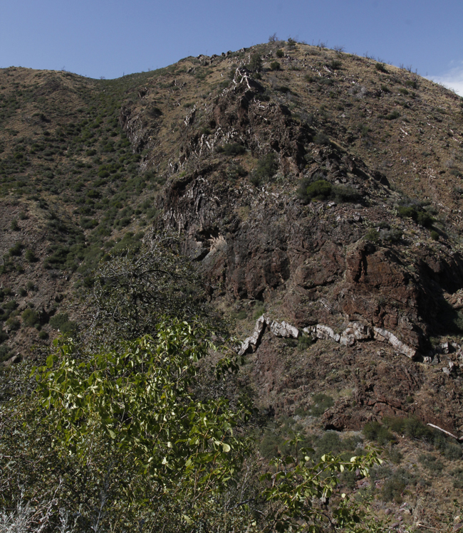
Here’s an overview shot:
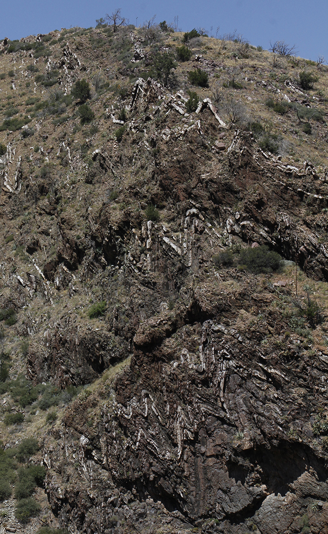
Now, let’s zoom in!
The first is a photo of an entire canyon wall covered in chevron folds. This is the upper part of the Maverick Shale with the quartzite layers surrounded by the shale, so you have ductile and brittle deformation at the same time. The height of this outcrop is about 200-300 feet.
Spectacular! I love it.
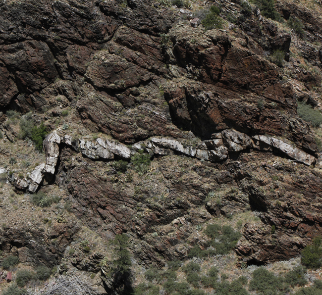
This photo is the same outcrop as the first photo, but lower on the wall. The quartzite layer is probably 2-3 feet thick and you can see a few agave plants for scale. You can see that shorting that the shale was able to withstand made the quartzite layer turn into a series of thrust faults and folds.
Thanks, Mike. These are great.
Other readers who want to send me candidates for the Friday fold series, please do!
Happy Friday, everyone.
Maverick shale indeed. If the quartzite layers metamorphosed, why not the surrounding the shale?
Lee,
The scale of these photos don’t show the metamorphism in the shale, but there is a lot of slaty cleavage and other small scale structures within the shale.
Mike
Hello Mike,
I live in Payson (about 15 miles from the Barnhardt Trail). This hike is one of my favorites. There are some Chevron folds on the trail side directly across from those you have posted—several are covered in lichens but still visible.
I’m interested in reading your MA on the geology of this location. Is it available on-line? Thanks, Gary
Gary,
I just now saw your question. My MA thesis is not online, but it should be available in the Northern Arizona University library.
Mike
Just found this: a GigaPan of the site:
http://gigapan.com/gigapans/165825
Callan,
Thanks for finding that GigaPan. The November lighting shows more detail than I’ve seen in my travels there. There are several horizontal fault planes visible above the thrust faulted quartzite layer. I can see at least 2 fault planes in the lighter brown shale that is above the quartzite layer and below the darker brown shale that contains the bulk of the chevron folds.
Thanks for finding and posting the link.
Mike
Callan,
The gigapan image is fantastic. I followed Mike P. and David Puls with additional mapping in Barnhardt Canyon for a Senior-MS Thesis in the Late 1980’s. I decided to follow-up with a PhD on a more regional scale in 2007 trying to sort out what happened within the interval between the Yavapai and Mazatzal orogenies using detrital zircon geochronology in addition to the published geochronologic framework. Turns out that there is good reason to believe that the timing of deformation of the rocks in Barnhardt Canyon is Mesoproterozoic. The Hopi Springs Shale, the highest Proterozoic stratigraphic unit in the range, occurring beneath the Barnhardt Thrust, contains a peak of detrital zircon ages ca. 1570 Ma, a similar result is found in an argillaceous unit in the core of the Four Peaks fold at Four Peaks to the south, and even earlier ages are found in the upper Salt River Canyon. It looks like the deformation in Barnhardt Canyon, clearly post-1571 Ma, likely occurred between 1470 and 1450 Ma. The Mazatzal Revolution of Wilson (1939), later renamed the Mazatzal orogeny by Silver (1965) is equivalent to the Picuris orogeny in New Mexico (Daniels et al, 2013).
The Picuris (Mazatzal) orogeny coincides with the filling of the Belt Supergroup (Jones et al., 2015).
Anyhow, I have a couple of interesting images of the folded quartzite with myself for scale. Plus an image of the prominent folded quartzite bed restored using Midland Valley’s Move structural restoration program. Not sure how or where to post these.
I also have a digital copy of Mike Pendergrass’s thesis (in color!), as well as others in the area. My MS and PhD work are also available.
Hi Michael,
Thanks for the additional insights!
If you want to email me the photos, I’ll be happy to post them here in a follow-up post.
C
Hi Mike, A question about the chevron folds along Barnhardt came up on this site:
https://www.reddit.com/r/geology/comments/lteovk/someone_please_explain_this_formation_for_me_rye/
I posted a link to ‘Friday Folds’ for cross-pollination. Do you have a link to your MA thesis.