Here’s one you can click through to make much bigger:
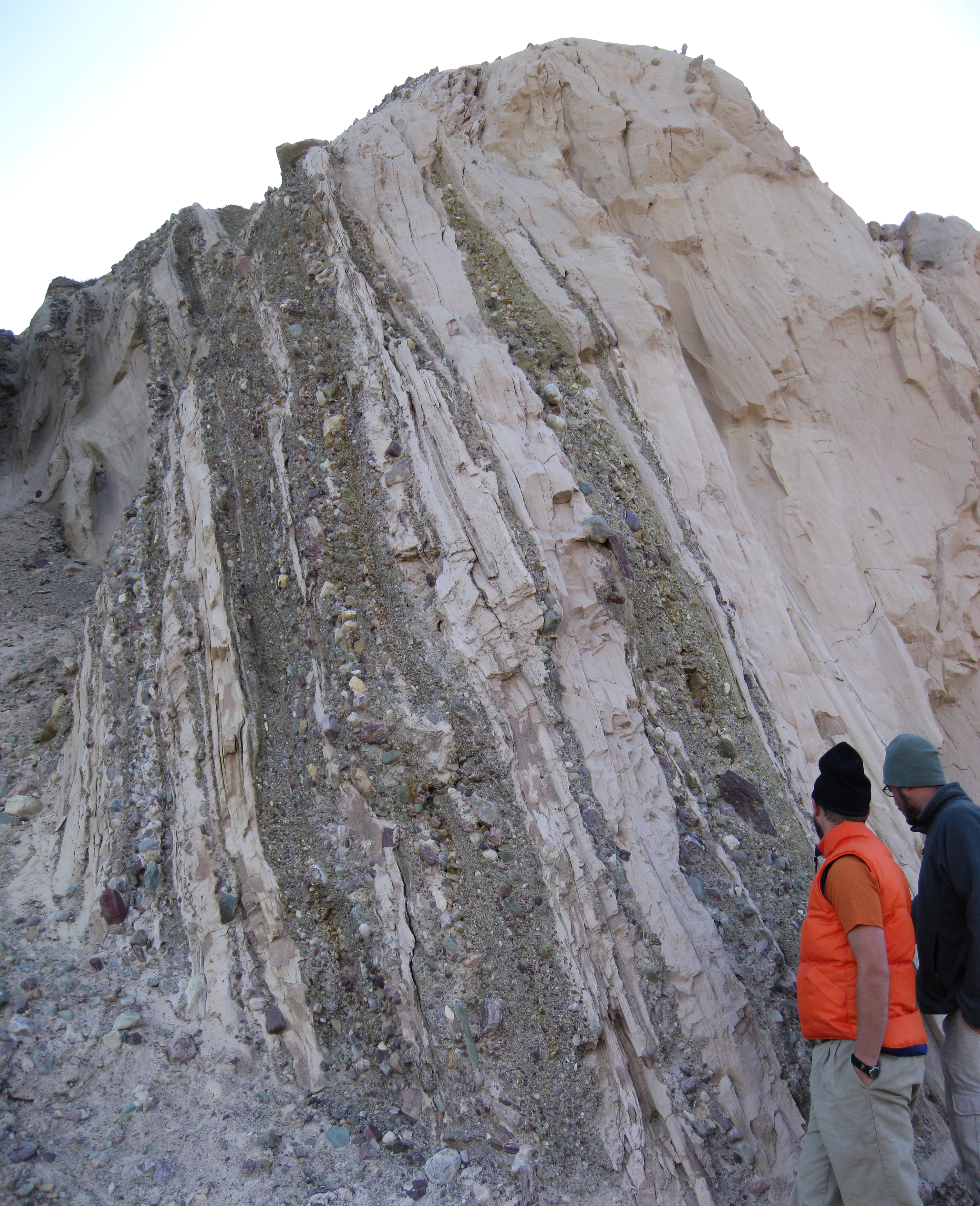
That’s a pretty cool outcrop that shows something amazing. Anyone want to take a stab at interpreting it?

Here’s one you can click through to make much bigger:
That’s a pretty cool outcrop that shows something amazing. Anyone want to take a stab at interpreting it?
I only have about two minutes b4 heading to meeting, so here’s my “gut instinct” interpretation: it looks to be slightly overturned (strat up is to the lower left); an intercalation of fine-grained sandstone and pebble-to-cobble conglomerate, looks like the conglomerate lenses are on surfaces cutting down into the sandstone a bit; some of the sandstone *might* have some combined-flow sed structures. So, maybe interbedded shallow marine and fluvial processes? I don’t know, I’m likely missing something really obvious right in front of my face.
Interbedded lahar and ashfall deposits, formed during a single eruption event!
Interbedded proglacial lacustrine (fine, silt/rock flour) and glaciofluvial outwash (gravel, sand) deposits, probably in northern Montana, judging by all the purple and green Belt-Purcell-like argillite clasts. Dropstones are visible in the fine sediments (lacustrine silt) at the top of the photo. I agree with Brian that “up” is to the left, based on scour surfaces. The whole package was then ice-thrusted by a subsequent advancement of the glacier, perhaps during the “Little ice age” a few hundred years ago?
After more careful examination of this image rotated/flipped, I’m less confident of the stratigraphic attitude of the beds. I see both normal and reverse grading in the gravel lenses, but this is probably to be expected in a laterally accreting anastomosing system. Some of the pebbles/cobbles protruding into the fine silts could be either “sinkers” from overlying gravel, or “stickups” from underlying gravel. I’ll stick with the overturned idea.
If I’d taken the time to click the “pretty cool outcrop” link, I wouldn’t have had to speculate about the location (red face). Lucky guess (ditto for the image file name!).
As for the near-vertical attitude of the beds, that’s the least difficult thing to explain. I’m sticking with my guess that the deposits were thrusted by a glacial advance, but seeing the context of the steep local topography, it could just as easily be explained as part of a rotated slump block or landslide deposit.
You’re totally on top of this, Howard. Nicely played!
wow, having not studied glacial systems in any detail I’m pretty blown away by this ice thrusting process … awesome
I like the glacial explanation from Howard Allen, and I would have suggested something along those lines (but not as specific), but the purple clasts concern me. I would have never considered it if Alton hadn’t mentioned it, but the only other comparable outcrop I’ve ever seen was in St. Lucia – a volcanic island. Can’t wait to hear the explanation!
I was thinking glacial out wash plain so yeah I’m going with Howard too.
I also like Howard Allen’s explanation, which is what immediately came to mind on examination of the geographic area. BUT, what would have caused it to tilt so much between then and now? So, I’m going with successive episodes of maybe even the same volcanic eruption between which the dust literally settles on the volcanic slope.
The first thing I thought of when I looked at the link to the location is the Lewis Thrust. Are there any Neoproterozoic glacial deposits sitting on the Lewis Thrust sheet? If there are, would that make them “snowball earth” deposits?
Definitely this location is very, very close to the trace of the Lewis Thrust. It’s a quarter-mile from outcrops of Cretaceous shales pulverized and twisted by that thrust sheet advancing over top of them.
I would love to take a trip with all of you. Have only done one Geo. field trip and it was the funnest two weeks in years.
That would be great, Dan – perhaps at the Geoblogger Rendezvous next summer? Or after the AGU meeting in San Francisco in December?
I don’t see overturning, indeed I see load structures on the left-hand sides of the rightmost thin conglomerate (diamictite) beds that indicate downward transport. Judging from the filename of the photo, this is glacio-fluvial stuff. The degree of tilting is a puzzle, assuming this is Pleistocene.
I’m with Andrew. The beds are steeply inclined but there is no overturning. Some conglomerates show normal grading. Anastomising channels in a glacial flood plain with quiet water areas? The fine sediments show load structures. In places the fine material was reworked with flow from “up” to “down”. I believe to see large current ripples or dunes in the fine sediment at the right but it might just be the distorted perspective of the foto. The sediments must have been sufficiently consolidated to survive such tilting without faulting and deformation (i see none). Without any clue of the geology in the US I’d guess it is older than the Pleistocene.
Good observations, Andrew and Lost. I noticed the same sorts of geopetal indicators.
Of course you could skip all the fancy geology by just looking at the name of the file . . . 🙂
Yeah, this really is a cool feature (no pun intended). Ice-thrusting can even act on bedrock in some places, not just these penecontemporaneous glacial deposits. For example, in the central Alberta plains there are road cuts along highway 56 south of Stettler that show folding and tilting in the Upper Cretaceous Horseshoe Canyon Fm. beds. Look at these coordinates in GE Streetview:
52.10329, -112.7193
52.11243, -112.71929
52.13658, -112.71929
These beds are plunk in the middle of the tectonically undisturbed Western Canada Sedimentary Basin, and have no business being tilted.
I should point out for the non-locals that this area was over-ridden by the Laurentide ice sheet, flowing from NE to SW. If you look at the first set of coordinates I gave, you can clearly see the series of NW-SE oriented thrust ridges crossing the highway. While you’re at it, check out the awesome knob-and-kettle topography, especially further south, near Big Valley.